Trail head: approximately 9.5 miles north of Boone. Take Hwy 194
Elk Knob State Park
5564 Meat Camp Road
Todd, NC 28684
Elk.knob@ncparks.gov
Camping reservation: 828-297-7261
After turning a right into the state park at the top of the mountain. You will follow a gravel road for a bit then park in the parking lot.
Distance: 3.8 miles out and back
GPS: 36.332586, -81.69064
Elevation Gain: 1000feet
At an elevation of 5520′ , Elk Knob is one of the ,tallest peaks in Watauga county with spectacular panoramic views of the surrounding landscape.
The trail starts off in the parking lot and the trailhead leads upwards in a zig zag fashion. At the 1 mile point you will see an opening with a great mountain view. There is also a bench here to rest your legs preparing for the next mile to the top of the mountain. When you get towards the top of the trees you are almost there. The path at the top says North and South. Get out your camera the views are amazing. Either one has spectacular panoramic views with display panels that identify the mountains views. There are also benches at the top to take in the views and rest a bit if needed.
Hiking Humpback Rocks is a relatively short hike following a 2.0-mile (3.2 km) trail loop. With a roughly 45-minute hike to ascend 740 feet (230 m) to the peak, and a 20-25-minute descent, this ranks as one of the shorter hikes along the Blue Ridge, however it remains one of the most rewarding. The peak affords a spectacular 360-degree view of the surrounding terrain. To the north you can see into the southern section of Shenandoah National Park, to the east check out the patchwork of farms, to the southwest you see thick woods and mountain ridges of the George Washington National Forest.
Hikers may continue to follow the Trail for .5 miles (0.80 km), passing along the top of a cliff with views to the south and east before descending 1.2 miles (1.9 km) to a blue blaze trail. This trail leads .3 miles (0.48 km) into the Humpback Rocks Picnic Area. The distance between Humpback Gap and the Humpback Rocks Picnic Area is 3.6 miles (5.8 km). A map of the hike and of the Humpback Gap Overlook is available through the Blue Ridge Parkway website.
Continuing past Humpback Rocks itself, the summit of Humpback Mountain is only a few minutes further. The Appalachian Trail is only a short hike to the north, at milepost 6.
The Humpback Rocks Visitors Center is located at milepost 5.8, six miles south of the Rockfish Gap Interchange of I-64 and US 250. It is most easily accessed by either one of these two highways. Head south on the Blue Ridge Parkway for 5.8 miles (9.3 km) to reach the Humpback Rocks Visitors Center, or continue another 0.2 miles (0.32 km) to arrive at the Humpback Gap parking area on the left.
The Appalachian Trail can also be accessed from the Humpback Gap parking area. Southbound hikers can reach it by continuing south on the Humpback Rocks trail. Northbound hikers can reach it taking the one mile (1.6 km) blue blazed path at the northern end of the parking lot, or the one mile (1.6 km) white blazed path just off of the Howardsville Turnpike.
Overview: This is a very family walking trail in Blowing Rock North Carolina. It is part of the Moses Cone Memorial Park Trail system. The hike is about one mile in length but is a beautiful walk around the lake during any season. This hiking trail is a great stretch your legs type of hike after you have been driving in the car all day. Pets are welcomed on this trail but must be on a leash. I would definitely recommend this hike during the fall season for a brisk walk and great picture taking.
Tips:
Make sure you have comfortable hiking shoes
You must sign your name to the Grandfather Mountain List for the Ranger
Bring plenty of water at least 2 bottles and a back pack
Bass Lake Loop Trail Map
Photo Gallery
*Click on thumbnails for larger viewing and slideshow
Video View From Flat Rock View on Grandfather Mountain
Overview:
This is one of the many longer hikes in Blowing Rock North Carolina. This hike is attached to the Moses Cone Memorial Park trail system called the Rich Mountain Carriage Trail.To get to the starting point get off the Blue Ridge Parkway the exit before you reach Moses Cone Manor and take a right if you are going North on the Blue Ridge Parkway. Head towards Shulls Mill Road, go under the Blue Ridge Parkway and pass Trout Lake on your right hand side. After Trout lake its about 1/2 mile on your right you will see a gate that looks like a private driveway. This is the start of the trail.You can park down below at the Trout Lake parking area and continue to the trail from there but add some more time and hiking upwards. We found a spot on the side of the road and pulled off and parked.
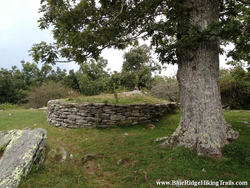
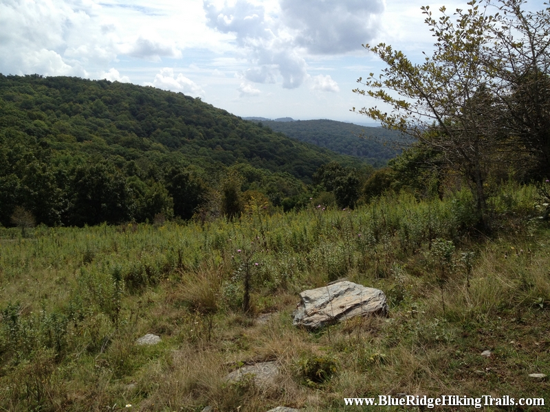
The hike is a nice gradual incline that winds its way to a very large pasture where you can go right to Trout Lake or continue straight and then go right or left which is a loop around. We decide to go left it was less steep and shaded with a woods canopy. The trail keeps going around the side of the mountain until you reach the upper meadow which is covered by many pretty wildflowers and butterflies. The trail continues to keep circling around the mountain until you reach the summit, where there is a brick wall and a nice oak tree to rest under for a few minutes.
This hike up and back from the gate took 2 hours and is 3.5 miles long. This hiking trail is great for families, dogs, and kids of younger ages. The trail is a very gradual incline and very wide enough for horses which frequent the trail.
Tips:
1. Bottle or two of water
2. Comfortable hiking shoes
3. Camera for pictures
4. Look at a map of the trail system before going
5. Park at Trout Lake if necessary