by admin | Aug 22, 2018 | Easy/Moderate Hiking Trails, Hiking By Difficulty, Hiking By Distance, Hiking Trail Guides by State, Hiking Trails - Over 1.0 Mile, Hiking Trails - Over 2.0 Miles, Hiking Trails - Over 3.0 Miles, North Carolina Mountain Hiking Trails, North Carolina State Park Trails, State Park Hiking Trails
Elk Knob Summit Trail
Trail head: approximately 9.5 miles north of Boone. Take Hwy 194
Elk Knob State Park
5564 Meat Camp Road
Todd, NC 28684
Elk.knob@ncparks.gov
Camping reservation: 828-297-7261
After turning a right into the state park at the top of the mountain. You will follow a gravel road for a bit then park in the parking lot.
Distance: 3.8 miles out and back
GPS: 36.332586, -81.69064
Elevation Gain: 1000feet
At an elevation of 5520′ , Elk Knob is one of the ,tallest peaks in Watauga county with spectacular panoramic views of the surrounding landscape.
The trail starts off in the parking lot and the trailhead leads upwards in a zig zag fashion. At the 1 mile point you will see an opening with a great mountain view. There is also a bench here to rest your legs preparing for the next mile to the top of the mountain. When you get towards the top of the trees you are almost there. The path at the top says North and South. Get out your camera the views are amazing. Either one has spectacular panoramic views with display panels that identify the mountains views. There are also benches at the top to take in the views and rest a bit if needed.
by admin | Nov 26, 2017 | Easy Hiking Trails, Easy/Moderate Hiking Trails, Hiking By Difficulty, Hiking By Distance, Hiking National Parks, Hiking Trails - Over 1.0 Mile, Hiking Trails - Over 2.0 Miles, Hiking Trails - Over 3.0 Miles, Hiking Trails - Under 1.0 Mile, Hiking Trails Blue Ridge Parkway VA, Overlook Hiking Trails, State Park Hiking Trails, Strenuous Hiking Trails, Virginia Overlook Mountain Trails, Virginia State Park Trails, Virginia Visitor Center Trails, Visitor Center Hiking Trails
Hiking Humpback Rocks is a relatively short hike following a 2.0-mile (3.2 km) trail loop. With a roughly 45-minute hike to ascend 740 feet (230 m) to the peak, and a 20-25-minute descent, this ranks as one of the shorter hikes along the Blue Ridge, however it remains one of the most rewarding. The peak affords a spectacular 360-degree view of the surrounding terrain. To the north you can see into the southern section of Shenandoah National Park, to the east check out the patchwork of farms, to the southwest you see thick woods and mountain ridges of the George Washington National Forest.
Hikers may continue to follow the Trail for .5 miles (0.80 km), passing along the top of a cliff with views to the south and east before descending 1.2 miles (1.9 km) to a blue blaze trail. This trail leads .3 miles (0.48 km) into the Humpback Rocks Picnic Area. The distance between Humpback Gap and the Humpback Rocks Picnic Area is 3.6 miles (5.8 km). A map of the hike and of the Humpback Gap Overlook is available through the Blue Ridge Parkway website.
Continuing past Humpback Rocks itself, the summit of Humpback Mountain is only a few minutes further. The Appalachian Trail is only a short hike to the north, at milepost 6.
The Humpback Rocks Visitors Center is located at milepost 5.8, six miles south of the Rockfish Gap Interchange of I-64 and US 250. It is most easily accessed by either one of these two highways. Head south on the Blue Ridge Parkway for 5.8 miles (9.3 km) to reach the Humpback Rocks Visitors Center, or continue another 0.2 miles (0.32 km) to arrive at the Humpback Gap parking area on the left.
The Appalachian Trail can also be accessed from the Humpback Gap parking area. Southbound hikers can reach it by continuing south on the Humpback Rocks trail. Northbound hikers can reach it taking the one mile (1.6 km) blue blazed path at the northern end of the parking lot, or the one mile (1.6 km) white blazed path just off of the Howardsville Turnpike.
by admin | May 25, 2015 | Campground Hiking Trails, Hiking By Activity, Hiking By Difficulty, Hiking By Distance, Hiking National Parks, Hiking Trail Guides by State, Hiking Trails - Over 2.0 Miles, Hiking Trails Blue Ridge Parkway NC, Moderate Hiking Trails, North Carolina Campground Trails, North Carolina Mountain Hiking Trails, North Carolina Overlook Mountain Trails, North Carolina Waterfall Trails, Overlook Hiking Trails, Waterfall Hiking Trails
Trail head: Milepost 296.7 Blue Ridge Parkway
Distance: 2 miles
Duration: 56 minutes
Skill Level: Moderate Hiking Trails
Overview:
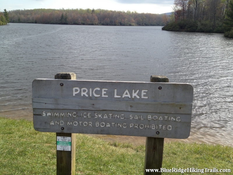
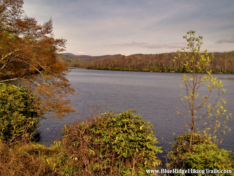
The Price Lake loop trail is part of the Julian Price memorial park trails. From the Parking lot at the front of the lake at milepost 296.7.We went left around the lake and followed the path through the rhododendrons as we passed many opening with different views of the lake. We saw people fishing, canoeing, and sitting on benches enjoying the sounds and breeze of the lake. The trail winds around sometimes very close to the shore of the lake and you will have to cross many small and large bridges on the trail. We even got to see beavers and the dam they built towards the back of the lake. We even passed the boathouse were you can rent canoes and kayak for an adventure on the lake. The lake is at an elevation of 3410 feet. Continue past the campground entrance and you will end of back at the parking lot where you started. Price Lake is a wonderful hike and is worth a first or second trip during the fall foliage.
Tips:
- Make sure you have comfortable shoes
- Make sure your pet is on a leash
- Family friendly trail
- Nice Lake Views
Price Lake Loop Trail Map
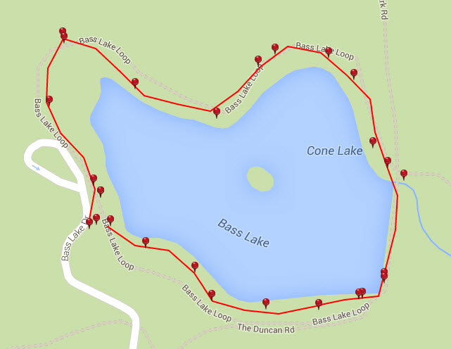
Photo Gallery
*Click on thumbnails for larger viewing and slideshow
by admin | May 25, 2015 | Campground Hiking Trails, Hiking By Activity, Hiking By Difficulty, Hiking By Distance, Hiking National Parks, Hiking Trail Guides by State, Hiking Trails - Over 2.0 Miles, Hiking Trails Blue Ridge Parkway NC, North Carolina Campground Trails, North Carolina Mountain Hiking Trails, North Carolina Overlook Mountain Trails, North Carolina Visitor Center Trails, North Carolina Waterfall Trails, Overlook Hiking Trails, Strenuous Hiking Trails, Visitor Center Hiking Trails, Waterfall Hiking Trails

Trail head: Milepost 316.4 Blue Ridge Parkway
Distance: 1.9 miles
Duration: 25 minutes
Skill Level: Strenuous Hiking Trails
Overview:
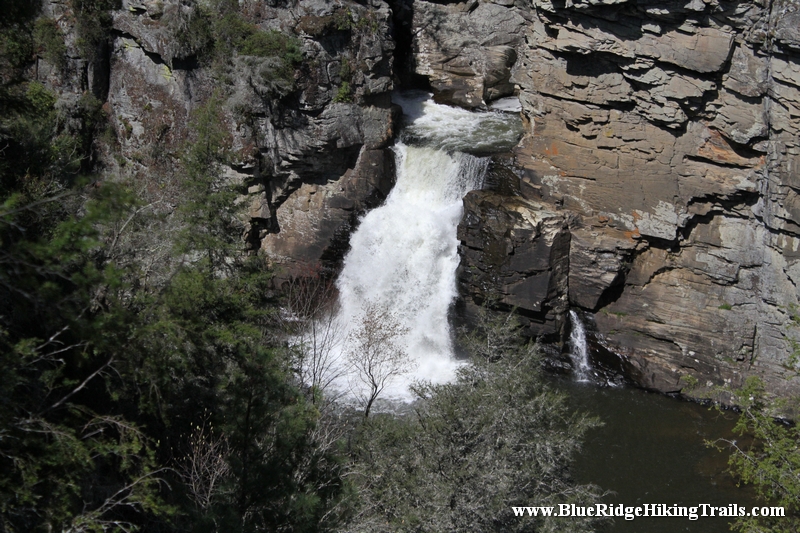
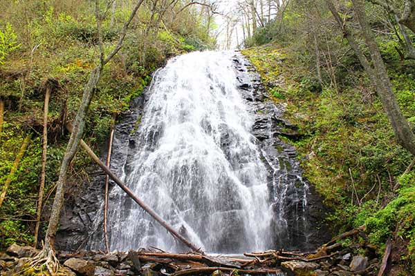
Linville Falls is one of the major attractions along the Blue Ridge Parkway at milepost 316. Linville falls is located in the Blue Ridge mountains of North Carolina and is the beginning of Linville Gorge; the waterfalls are fed from the Linville River and flows down the mountain into Lake James near Marion, North Carolina.
There are two main trails to see the Linville Falls and upper trail and lower trail. This trip we took the upper trail Erwin’s View Trail and is approximately 0.8 miles; 1.6 miles round trip taking 45 minutes to 1hr and 30 minutes. Starting from the Linville Falls Visitor Center the 0.5 mile hike takes you to an overlook where visitors can see the two upper falls and the rushing water as it carves out the rock falling 150ft to the main waterfall. The Erwin’s View trail leads to 2 more overlooks, the Chimney overlook (0.7 miles) and Erwin’s View overlook (0.8 miles).Each overlook has a great view of the waterfalls and the Linville Gorge and a picture is well worth a thousand words once you reach the overlooks.
Tips:
- Make sure you go to the bathroom at the visitor center before you start your hike whether you take the upper or lower trail.
- Make sure you bring a water bottle.
- Make sure you bring a camera for pictures.
- Make sure you wear sneakers or hiking shoes.
Linville Falls Trail Map
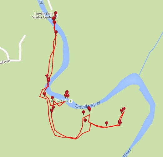
Photo Gallery
*Click on thumbnails for larger viewing and slideshow
by admin | May 25, 2015 | Campground Hiking Trails, Hiking By Activity, Hiking By Difficulty, Hiking By Distance, Hiking National Parks, Hiking Trail Guides by State, Hiking Trails - Over 2.0 Miles, Hiking Trails Blue Ridge Parkway NC, Moderate/Strenuous Hiking Trails, North Carolina Campground Trails, North Carolina Mountain Hiking Trails, North Carolina Overlook Mountain Trails, North Carolina Visitor Center Trails, North Carolina Waterfall Trails, Overlook Hiking Trails, Visitor Center Hiking Trails, Waterfall Hiking Trails
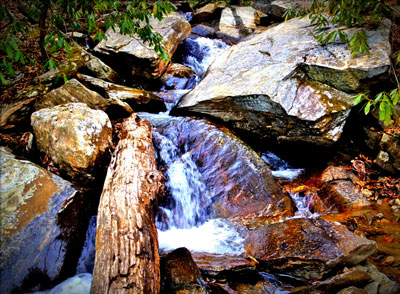
Trail head: Milepost 339.5 Blue Ridge Parkway
Distance: 2.6 miles
Duration: 2 hrs
Skill Level: Moderate/Strenuous Hiking Trails
Tips:
- Make sure you have comfortable hiking shoes
- There is a bathroom and a water fountain at the parking lot
- Waterfall Picture taking bring camera
Crabtree Falls Loop Trail Map
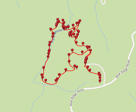
Photo Gallery
*Click on thumbnails for larger viewing and slideshow
by admin | Apr 8, 2013 | Hiking By Activity, Hiking By Difficulty, Hiking By Distance, Hiking National Parks, Hiking Trail Guides by State, Hiking Trails - Over 2.0 Miles, Hiking Trails Blue Ridge Parkway NC, North Carolina Mountain Hiking Trails, North Carolina Overlook Mountain Trails, North Carolina Visitor Center Trails, Overlook Hiking Trails, Strenuous Hiking Trails, Visitor Center Hiking Trails, Waterfall Hiking Trails
Trail head: Milepost 299 Blue Ridge Parkway
Distance: 2.1 miles
Duration: 2 hrs
Skill Level: Very Strenous
Overview:
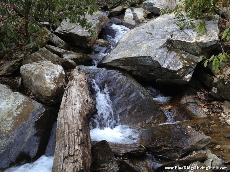
Gully Creek Trail starts at the Blue Ridge Visitor Center, Cumberland Knob, at milepost 217.5 off the Blue Ridge Parkway. Go past the visitor center from the parking lot and look towards the view behind the building and turn left. This is the start of the trail. At the trail head there is a sign Warning: strenuous 2.1 miles, well they were right. The first 10-15 minutes are not difficult as you go back and forth down the mountain. The sides of the trail are dangerous and very steep, one wrong step and you will fall down the mountain. You must be careful and pay attention at all times until you get closer to the bottom near the stream. Gully Creek Trail is one of the most difficult trails I have traversed due to the rushing water coming down the creek towards the bottom of the mountain. The water is running very fast in many places over the rocks where there is no crossing rocks to step on. We had to go ankle deep in some spots and slipped a few times on the rocks. We went very slow and still ended up with some scrapes and bruises. Once you are close to the bottom you are in a ravine following the creek down valley. Here the trail crosses many times back and forth across the creek. This continues until you reach the one mile point and your final crossing leads you past a ragged rock on your right side and then you start the ascent and climb up the other side.
The path starts off kind of easy and then gets harder as your legs get tired until you reach a flatter spot in the trail; you think that you are at the top and the trail then continues upward likes it never ends winding back and forth across the mountain. This part is about 0.7 miles long until you reach a fork in the road (a good resting spot and a quick drink of water) where you can continue straight towards the picnic area bringing you back to the visitor center and parking lot. We chose to go left which takes you up another steep hill for 0.4 miles until you reach Cumberland Knob. At the top you will see a shelter with with a fireplace and a grassy flat area. The trail continues past the shelter and starts down hill and comes out at the visitor center and the parking lot.
Tips:
This trail is not for younger kids that have not been hiking before, my daughter who is seven years old was able to do it with a lot of help from me crossing the creek. This is not a beginner trail at all, make sure you have plenty of water, a backpack with new socks and good hiking boots.
Photo Gallery
*Click on thumbnails for larger viewing and slideshow
