by admin | May 11, 2015 | Easy/Moderate Hiking Trails, Hiking By Activity, Hiking By Difficulty, Hiking By Distance, Hiking National Parks, Hiking Trail Guides by State, Hiking Trails - Over 5.0 Miles, Hiking Trails Blue Ridge Parkway NC, North Carolina Mountain Hiking Trails, North Carolina Overlook Mountain Trails, North Carolina Visitor Center Trails, Overlook Hiking Trails, Visitor Center Hiking Trails
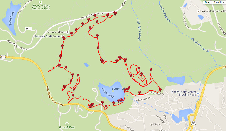
Trail head: Milepost Blue Ridge Parkway, Moses Cone Manor
Distance: 5.8 miles
Duration: 2 hours
Skill Level: Easy/Moderate Hiking Trails
Overview:
Tips:
Take a few bottles of water
Wear walking, running or hiking shoes
Be careful and courteous to Horses passing by
Moses Cone Park Carriage Trail Map
Photo Gallery
*Click on thumbnails for larger viewing and slideshow
by admin | May 11, 2015 | Easy/Moderate Hiking Trails, Hiking By Activity, Hiking By Difficulty, Hiking By Distance, Hiking National Parks, Hiking Trail Guides by State, Hiking Trails - Over 3.0 Miles, Hiking Trails Blue Ridge Parkway NC, Mountain Bike Trails, North Carolina Mountain Bike Trails, North Carolina Mountain Hiking Trails, North Carolina Visitor Center Trails, Visitor Center Hiking Trails
Trip Location: Blowing Rock, North Carolina
Length: 3.5 miles
Duration: 2 hours
Overview:
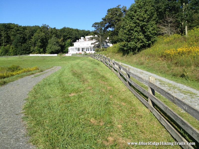
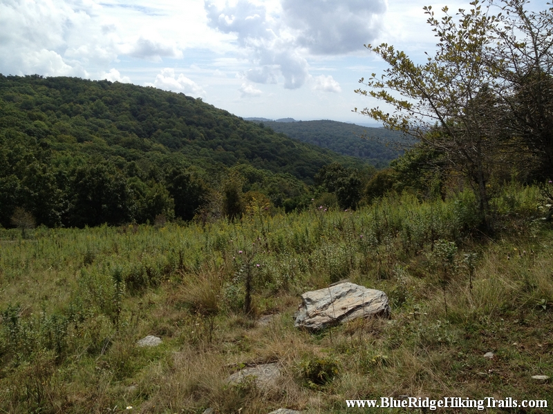
This is one of the many longer hikes in Blowing Rock North Carolina. This hike is attached to the Moses Cone Memorial Park trail system called the Rich Mountain Carriage Trail.To get to the starting point get off the Blue Ridge Parkway the exit before you reach Moses Cone Manor and take a right if you are going North on the Blue Ridge Parkway. Head towards Shulls Mill Road, go under the Blue Ridge Parkway and pass Trout Lake on your right hand side. After Trout lake its about 1/2 mile on your right you will see a gate that looks like a private driveway. This is the start of the trail.You can park down below at the Trout Lake parking area and continue to the trail from there but add some more time and hiking upwards. We found a spot on the side of the road and pulled off and parked.
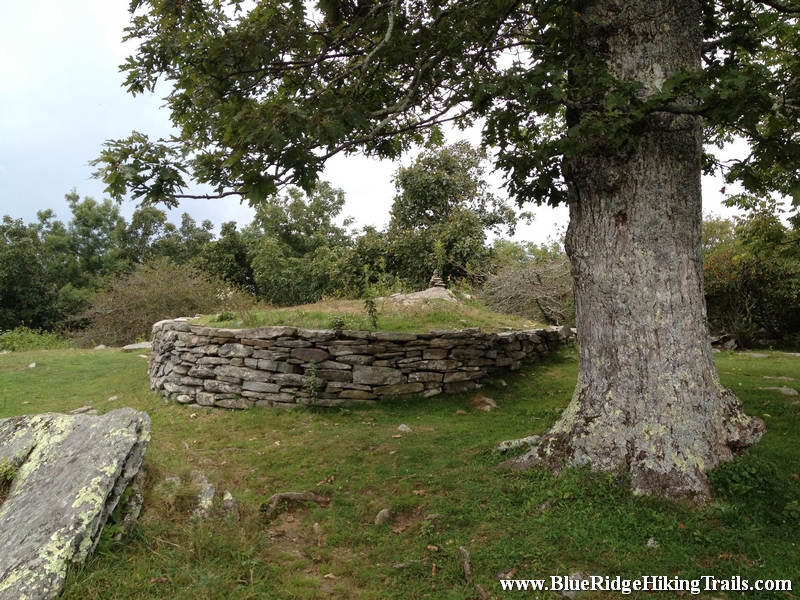
The hike is a nice gradual incline that winds its way to a very large pasture where you can go right to Trout Lake or continue straight and then go right or left which is a loop around. We decide to go left it was less steep and shaded with a woods canopy. The trail keeps going around the side of the mountain until you reach the upper meadow which is covered by many pretty wildflowers and butterflies. The trail continues to keep circling around the mountain until you reach the summit, where there is a brick wall and a nice oak tree to rest under for a few minutes.
This hike up and back from the gate took 2 hours and is 3.5 miles long. This hiking trail is great for families, dogs, and kids of younger ages. The trail is a very gradual incline and very wide enough for horses which frequent the trail.
Tips:
1. Bottle or two of water
2. Comfortable hiking shoes
3. Camera for pictures
4. Look at a map of the trail system before going
5. Park at Trout Lake if necessary
by admin | May 11, 2015 | Easy/Moderate Hiking Trails, Hiking By Activity, Hiking By Difficulty, Hiking By Distance, Hiking National Parks, Hiking Trail Guides by State, Hiking Trails - Over 4.0 Miles, Hiking Trails Blue Ridge Parkway NC, Mountain Bike Trails, North Carolina Mountain Bike Trails, North Carolina Mountain Hiking Trails, North Carolina Visitor Center Trails, Visitor Center Hiking Trails
Trip Location: Blowing Rock, North Carolina
Length: 4.7 miles
Duration: 2 hours
Overview:
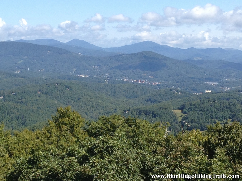
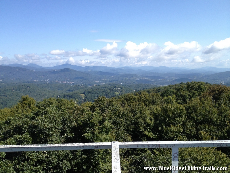
Flat Top Tower I have heard of before, but soon realized it was part of the Moses Cone Memorial Park Trail system off the Blue Ridge Parkway. I would put this up there as one of my Top 10 hikes so far just because of the 360 degree views from the tower. It gave me a better perspective of where I live and the lay of the land and how the towns are situated inside the mountain valleys. This is a must picture taking location and make sure you bring the telephoto lens.
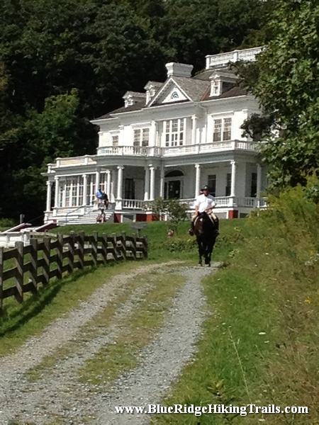
The hike starts out at the Moses Cone Memorial manor Parking Lot. Head down the steps with the manor on your right and take a left towards the stables. You will see a tunnel under the Blue Ridge Parkway go through it and bear right up the hill. This part of the trail winds back and forth climbing the mountain until you reach a large meadow. Keep going straight until you reach the sign. If you want you can check out the Moses Cone grave site which is fenced in.
The trail continues through the meadow and winds upward where there are many spots to see the mountains around you and to take some photos. To the left is Grandfather Mountain and you can see houses on the hill which is Seven Devils and Beech Mountain. To the right is Blowing Rock and more of the Blue Ridge Mountains.
The second part of the trail gradually has more of an incline as yo make your way toward the top where the tower is. There are many openings along the trail for a great photo or quick water break. The real beauty is when you finally reach the fire tower. (Note: If you are scared of heights this tower is not for you, if you want to you can climb up enough to get a glimpse of the view without being at the top of the tower). The top of the tower brings you up above the tree line where you can see 360 degrees of Blue Ridge Mountains. As you come up the last step you will be facing South toward Blowing Rock. To the right you can see Grandfather Mountain and even Price Lake, Seven Devils and Beech Mountain. Turning around and facing toward the North you will see Boone and can see the top of the buildings from Appalachian State University. This is a great view and completely worth the hike.
Tips:
1. Bottle of water
2. Comfortable Hiking Shoes
3. Great For Kids over 6 years old
4. No Bicycles allowed , be aware of horseback riding
5. Do not climb tower if afraid of heights
6. Best 360 degree view of the high country
7. Make sure its not a windy day when climbing the tower
by admin | Apr 8, 2013 | Hiking By Activity, Hiking By Difficulty, Hiking By Distance, Hiking National Parks, Hiking Trail Guides by State, Hiking Trails - Over 2.0 Miles, Hiking Trails Blue Ridge Parkway NC, North Carolina Mountain Hiking Trails, North Carolina Overlook Mountain Trails, North Carolina Visitor Center Trails, Overlook Hiking Trails, Strenuous Hiking Trails, Visitor Center Hiking Trails, Waterfall Hiking Trails
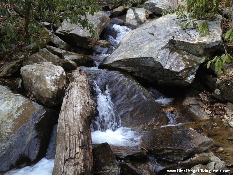
Trail head: Milepost 299 Blue Ridge Parkway
Distance: 2.1 miles
Duration: 2 hrs
Skill Level: Very Strenous
Overview:
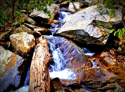
Gully Creek Trail starts at the Blue Ridge Visitor Center, Cumberland Knob, at milepost 217.5 off the Blue Ridge Parkway. Go past the visitor center from the parking lot and look towards the view behind the building and turn left. This is the start of the trail. At the trail head there is a sign Warning: strenuous 2.1 miles, well they were right. The first 10-15 minutes are not difficult as you go back and forth down the mountain. The sides of the trail are dangerous and very steep, one wrong step and you will fall down the mountain. You must be careful and pay attention at all times until you get closer to the bottom near the stream. Gully Creek Trail is one of the most difficult trails I have traversed due to the rushing water coming down the creek towards the bottom of the mountain. The water is running very fast in many places over the rocks where there is no crossing rocks to step on. We had to go ankle deep in some spots and slipped a few times on the rocks. We went very slow and still ended up with some scrapes and bruises. Once you are close to the bottom you are in a ravine following the creek down valley. Here the trail crosses many times back and forth across the creek. This continues until you reach the one mile point and your final crossing leads you past a ragged rock on your right side and then you start the ascent and climb up the other side.
The path starts off kind of easy and then gets harder as your legs get tired until you reach a flatter spot in the trail; you think that you are at the top and the trail then continues upward likes it never ends winding back and forth across the mountain. This part is about 0.7 miles long until you reach a fork in the road (a good resting spot and a quick drink of water) where you can continue straight towards the picnic area bringing you back to the visitor center and parking lot. We chose to go left which takes you up another steep hill for 0.4 miles until you reach Cumberland Knob. At the top you will see a shelter with with a fireplace and a grassy flat area. The trail continues past the shelter and starts down hill and comes out at the visitor center and the parking lot.
Tips:
This trail is not for younger kids that have not been hiking before, my daughter who is seven years old was able to do it with a lot of help from me crossing the creek. This is not a beginner trail at all, make sure you have plenty of water, a backpack with new socks and good hiking boots.
Photo Gallery
*Click on thumbnails for larger viewing and slideshow