by admin | May 11, 2015 | Easy Hiking Trails, Hiking By Activity, Hiking By Difficulty, Hiking By Distance, Hiking National Parks, Hiking Trail Guides by State, Hiking Trails - Under 1.0 Mile, Hiking Trails Blue Ridge Parkway NC, North Carolina Mountain Hiking Trails, North Carolina Overlook Mountain Trails, Overlook Hiking Trails

Trail head: Obids, North Carolina
Distance: 0.9 miles
Duration: 29 minutes
Skill Level: Easy
Overview:
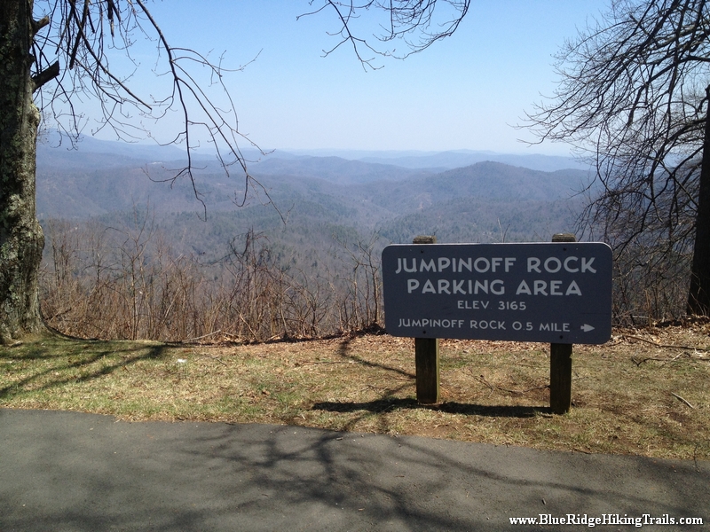
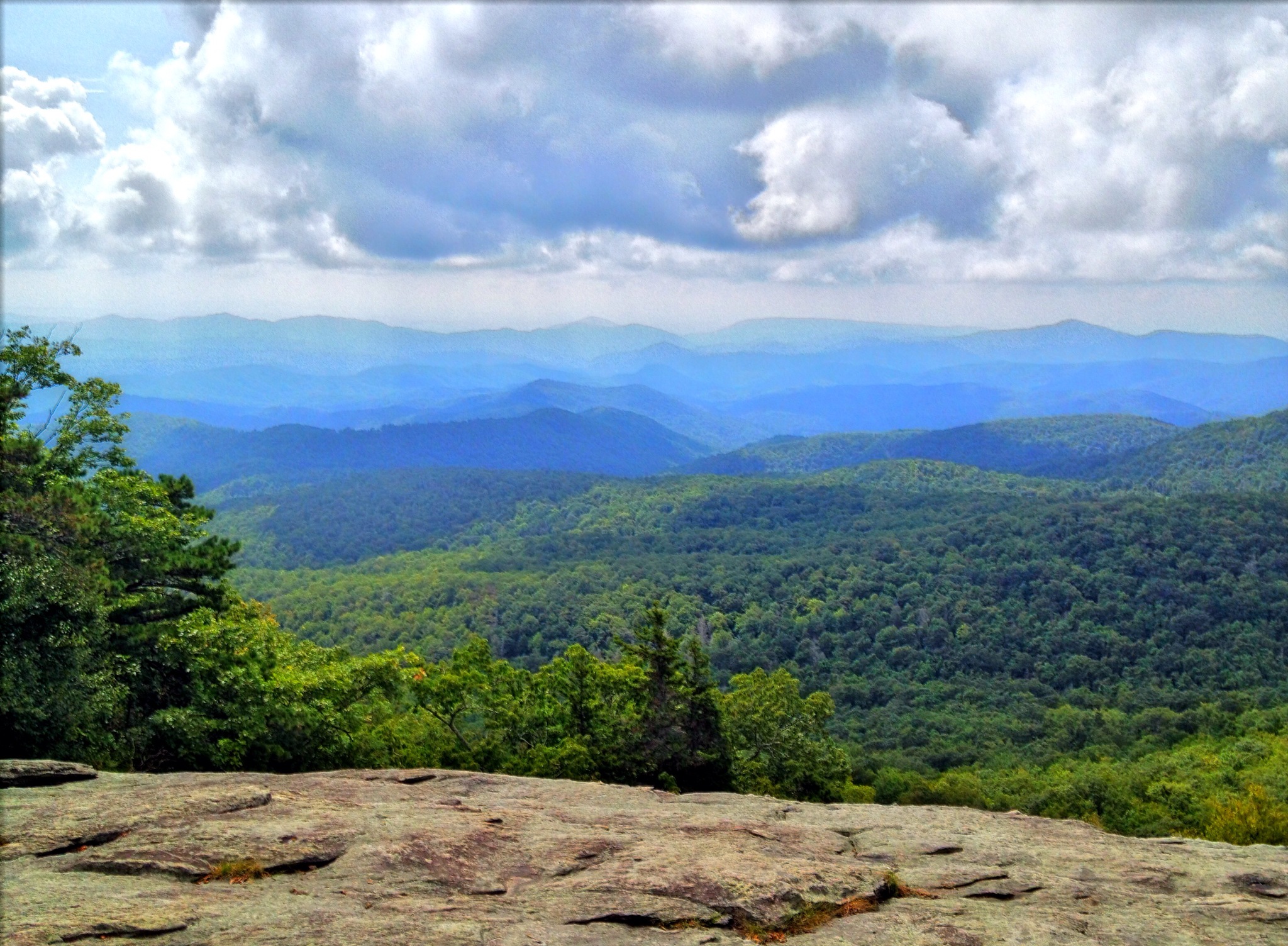
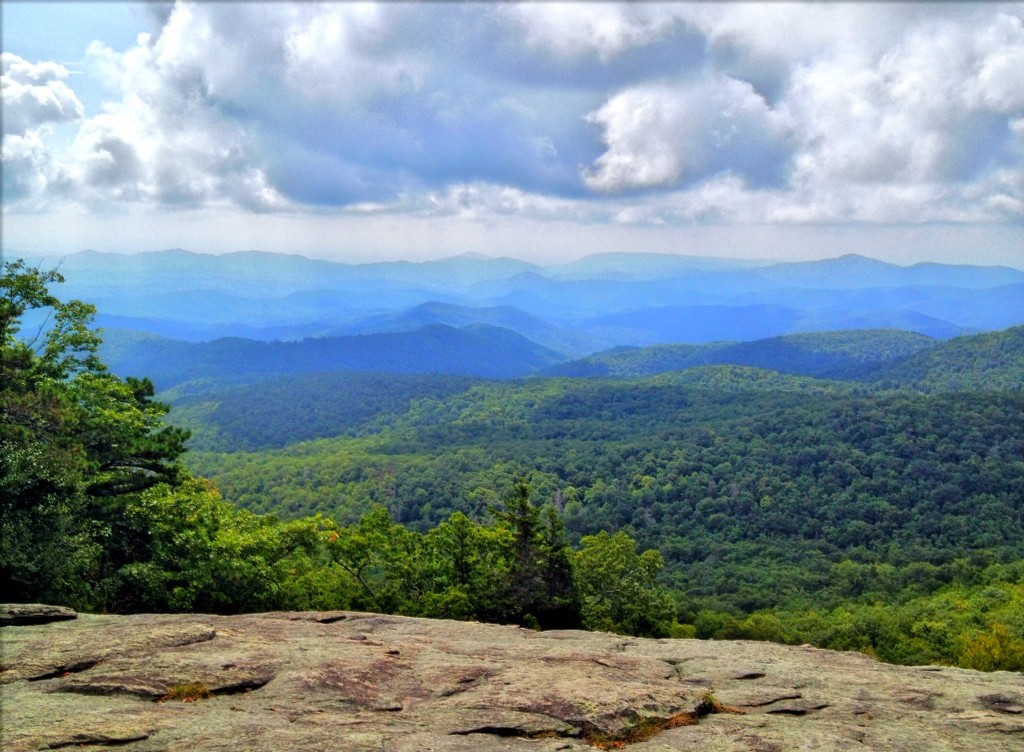
Jumpinoff Rocks Overlook is located on the right side of the Blue Ridge parkway while driving North at milepost 260.3. This is a great 1.0 mile hike to park in the overlook and stretch your legs after a long drive. There are beautiful scenic views from the parking lot and the overlook that is .5 miles at the end of the trail. There is also a picnic table fr sitting and relaxing with a great mountain view. First park your car and head right up the steps up a gradual hill climb. This trail is also part of the Mountain Sea Trail which is marked with the hiking man and a white dot. The trail continues with some flat parts and gradual inclines, but most part its a pleasant hike through the woods. The pat comes to a fork where if you turn right you continue on the Mountain Sea Trail, but you want to turn left to the overlook. from the fork the overlook is about fifty feet where you can step out into a clearing and see a 180 degree view of the mountains. Great spot for pictures and video, i will be returning again when its green and in the fall. The trail is then another .5 miles back to the car.
Tips:
- Great hike to stretch your legs after driving
- Perfect hiking trail for kids and very safe
- Bring a bottle of water and hiking shoes
- You could wear sneakers on this hike and be fine as well
Jumpinoff Rocks Trail Map
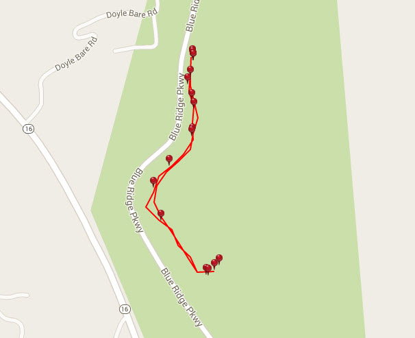
Photo Gallery
*Click on thumbnails for larger viewing and slideshow
by admin | Mar 28, 2015 | Easy/Moderate Hiking Trails, Hiking By Activity, Hiking By Difficulty, Hiking By Distance, Hiking National Parks, Hiking Trail Guides by State, Hiking Trails - Under 1.0 Mile, Hiking Trails Blue Ridge Parkway NC, North Carolina Mountain Hiking Trails, North Carolina Overlook Mountain Trails, Overlook Hiking Trails
Trail head: Milepost 305 Blue Ridge Parkway
Distance: 0.4 miles
Duration: 17 minutes
Skill Level: Easy/Moderate Hiking Trails
Overview:
Near Grandfather mountain at milepost 305 is the trail head for this great hike. At the trail head park your car in the lot, and walk across the road you will see the sign to beacon heights trail. The trail winds upward with many rocks. You will come to a fork in the Tanawha trail where you will go right. There are many rock formations you will see on the trail. Be careful of the rocks when its damp they can get slippery. Then you come to another fork at the mountains to sea trail where you go left. There are a benches along the way to sit and rest. The trail continues upward to finally almost like a rock staircase, to a huge rock ledge with an amazing view of the blue ridge mountains. This is a great spot to bring a picnic, relax, take some photos, or just take in the views. This is a prime spot for fall foliage photos.
Tips:
- Hiking shoes and water bottle
- Bring the camera for this view
Beacon Heights Trail Map
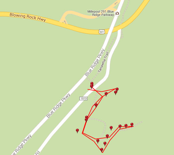
Photo Gallery
*Click on thumbnails for larger viewing and slideshow
by admin | Mar 28, 2015 | Easy Hiking Trails, Hiking By Difficulty, Hiking By Distance, Hiking National Parks, Hiking Trail Guides by State, Hiking Trails - Under 1.0 Mile, Hiking Trails Blue Ridge Parkway NC, North Carolina Mountain Hiking Trails, North Carolina Overlook Mountain Trails, Overlook Hiking Trails
Trail head: Milepost 299 Blue Ridge Parkway
Distance: 0.2 miles
Duration: 6 minutes
Skill Level: Easy
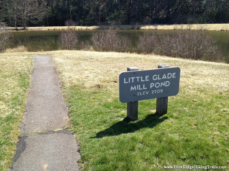
Overview: Little Glade Mill Pond-Blue Ridge Parkway-Milepost 230.1 is about 0.2 miles long and located near Cherry Lane, North Carolina. The trail is great for hiking and normally takes 1 hour or less.
Little Glade Mill Pond is located off the Blue Ridge Parkway at milepost 230.1. This overlook does not have a view at all but a convergence of two streams and a pond in the middle. This is a great .4 mile hike around the pond and back to your car; perfect for stretching your legs after a long drive. Safe place to let the kids out to run around around. There are picnic tables here as well as nice sunny and shady areas to spread a blanket.
Tips:
- Safe place to let the kids out to run around around.
- Great spot for a picnic or something to drink.
- Do not need any hiking shoes for this walk.
Little Glade Mill Pond Trail Map
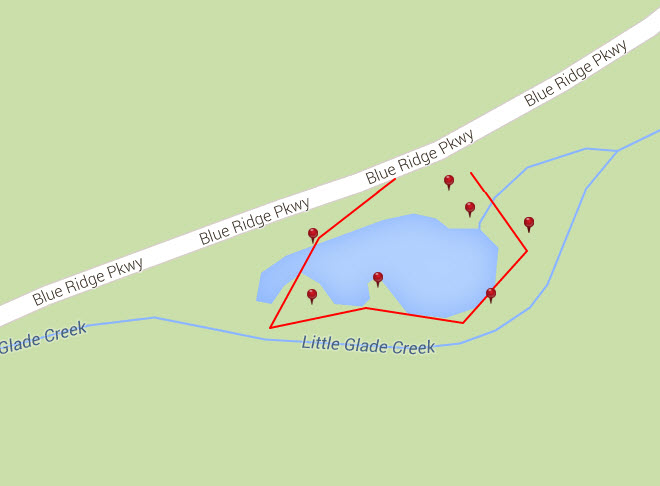
Photo Gallery
*Click on thumbnails for larger viewing and slideshow
by admin | Feb 19, 2014 | Easy Hiking Trails, Hiking By Activity, Hiking By Difficulty, Hiking Trails - Under 1.0 Mile, North Carolina Overlook Mountain Trails, North Carolina State Park Trails, North Carolina Waterfall Trails, Overlook Hiking Trails, State Park Hiking Trails, Waterfall Hiking Trails
Trail head: Millbrook Estates, North Carolina
Distance: 0.01 miles
Duration: 1 minute
Skill Level: Easy
Overview:
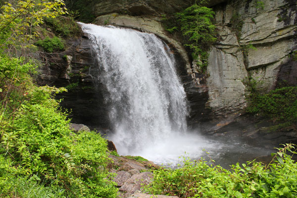
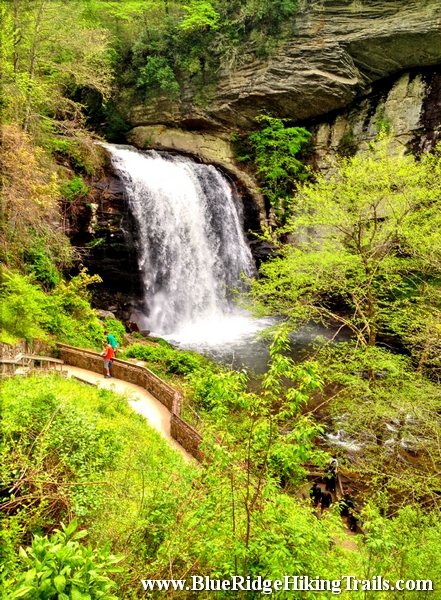
On your way to Brevard North Carolina on highway 64 there is an intersection whereabouts you take a left to Brevard on route 276 or to go into the Pisgah Forest. Go straight at the light and follow 276 North. Follow the Davidson River on the left hand side and go a 5.6 miles. At the fork in the road stay right and Looking Glass Falls is up on the right hand side.Looking Glass Falls is in the Pisgah Forest and open to the public year round. This waterfall is one of the more popular falls due to the visibility from the road.The waterfall has one drop and is 60 feet tall. There is a step path that takes you to the bottom and the plunge pool where many people take pictures and video. Its also kid friendly, accessible by wheelchair at the upper view, and swimming is allowed at the base of the pool. Looking Glass Falls is a great motorcycle waterfall to ride up to take some memorable photos and move onto the next waterfall down the same road route 276.
- Kid Friendly
- Upper View wheelchair access
- Steps to the bottom
- Swim at your own risk
- Visible from the road
Photo Gallery
*Click on thumbnails for larger viewing and slideshow
by admin | Apr 8, 2013 | Easy Hiking Trails, Hiking By Activity, Hiking By Difficulty, Hiking By Distance, Hiking Trails - Under 1.0 Mile, Hiking Trails Blue Ridge Parkway NC, North Carolina Mountain Hiking Trails, North Carolina Overlook Mountain Trails, Overlook Hiking Trails
Trail head: Walsh, North Carolina
Distance: 0.2 miles
Duration: 9 minutes
Skill Level: Easy
Overview:
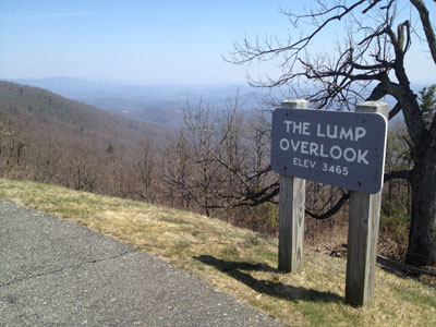
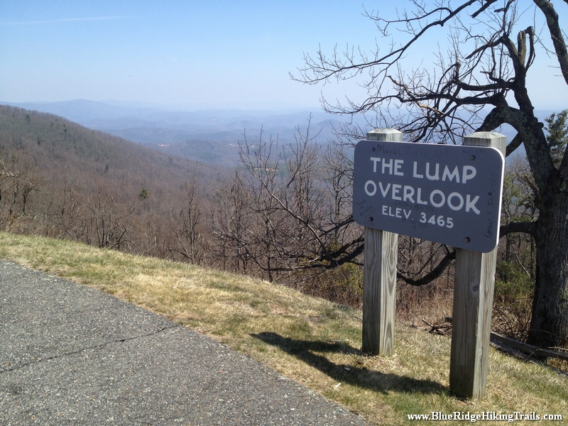
The Lump Trail is located at milepost 264.4 off the Blue Ridge Parkway. The Lump Trail is an extremely short hike up the adjacent hill behind the fence and is 0.3 miles up the hill and back. The Lump Trail has a beautiful scenic view of the mountains from the overlook and an even better view from the top of the hill. To the left of the overlook sign is a picnic table with a view. Also the top of the hill is a great place to stop, get some sun, and have a picnic.
Photo Gallery
*Click on thumbnails for larger viewing and slideshow
