by admin | May 18, 2015 | Hiking By Activity, Hiking By Difficulty, Hiking By Distance, Hiking National Parks, Hiking Trails - Under 1.0 Mile, Hiking Trails Blue Ridge Parkway NC, Moderate Hiking Trails, North Carolina Overlook Mountain Trails, North Carolina Visitor Center Trails, North Carolina Waterfall Trails, Overlook Hiking Trails, Visitor Center Hiking Trails, Waterfall Hiking Trails
Trail head: Milepost 271.9 Blue Ridge Parkway
Distance: 0.9 miles
Duration: 55 minutes
Skill Level: Moderate Hiking Trail
Overview:
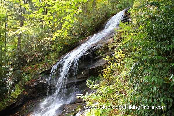
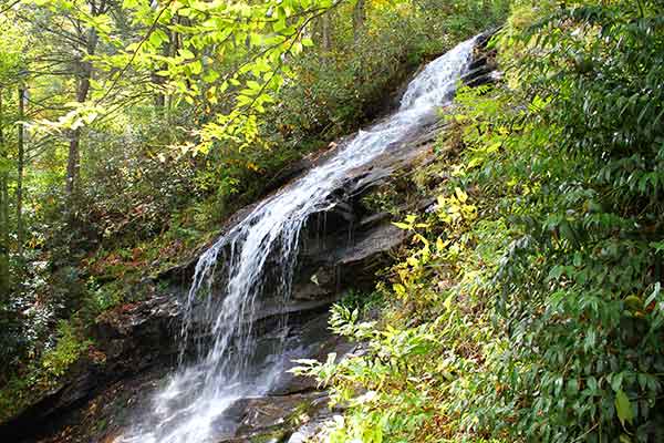
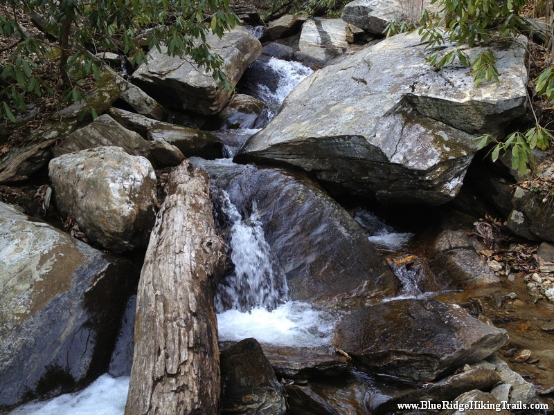
Trail head starts off at the E.B.Jeffress Park overlook at milepost 271.9 on the Blue Ridge Parkway. Past the bathrooms and down the trail the path takes you until you reach a series of steps, the a bridge that crosses Falls Creek which is part of the water for the Cascades waterfall. As you continue down the trail to see and step down many sets of stairs until you come to a stone staircase which leads you to more stairs downwards until you reach the cascades falls. The water fall runs from right to left and is many stories tall. Once you take your photos and head back up a few flights of stairs you then head towards the right and loop around towards the parking lot. there are many picnic benches here for lunch or a snack before or after your hike.
Tips:
- Water bottle
- Regular shoes or sneakers would be fine for this hike
- Would recommend this hike to families with small kids
Cascades Trail Map
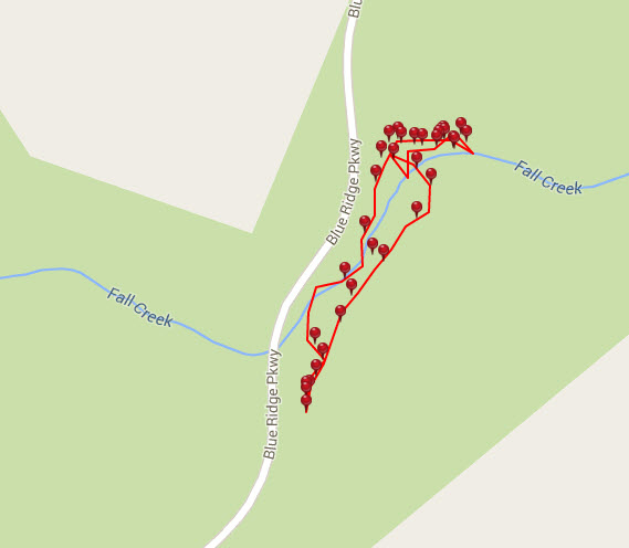
Photo Gallery
*Click on thumbnails for larger viewing and slideshow
Directions To The Cascades Waterfall
by admin | May 17, 2015 | Hiking 101, Hiking By Activity, Hiking By Difficulty, Hiking By Distance, Hiking Trail Guides by State, Hiking Trails - Over 1.0 Mile, Local Park Hiking Trails, Moderate/Strenuous Hiking Trails, North Carolina Local Park Trails, North Carolina Mountain Hiking Trails, North Carolina Waterfall Trails, Waterfall Hiking Trails
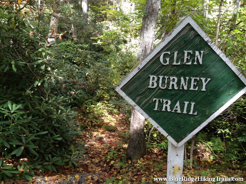
Trail head: Broyhill Park Blowing Rock NC
Distance: 1.2 miles
Duration: 1 hr
Skill Level: Moderate/Strenuous Hiking Trails
Overview:
The trail head is just past the Broyhill Park in Blowing Rock North Carolina. This hikes starts down a road then crosses a stream to some stair on onto the path you go. The trail weaves past houses along a fence, down some hills and following along the creek through the rhododendrons. This half of the hike is all down hill, but remember coming back is all on the upward side. Its worth it though seeing the 3 beautiful waterfalls. There are even areas to walk out over or next to the waterfalls on the Glen Burney hiking trail. Make sure you bring your phone or camera for some photo moments.
Tips:
- Water bottle
- Hiking shoes recommended
- Would recommend this for hikers that like waterfalls
Glen Burney Trail Map
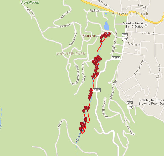
Photo Gallery
*Click on thumbnails for larger viewing and slideshow
by admin | May 11, 2015 | Campground Hiking Trails, Hiking By Activity, Hiking By Difficulty, Hiking By Distance, Hiking National Parks, Hiking Trails - Over 1.0 Mile, Hiking Trails Blue Ridge Parkway NC, Moderate Hiking Trails, North Carolina Campground Trails, North Carolina Overlook Mountain Trails, North Carolina Waterfall Trails, Overlook Hiking Trails, Waterfall Hiking Trails
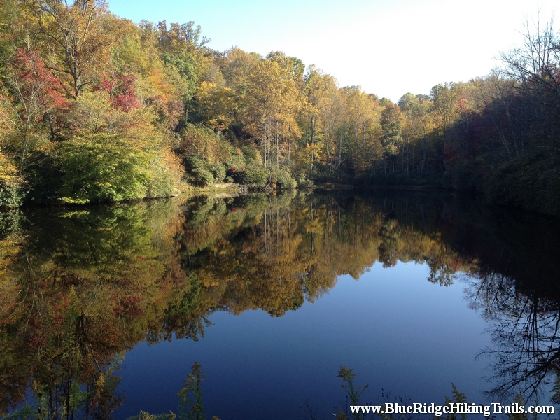
Trail head: Blue Ridge Parkway-Milepost 295.9
Distance: 2 miles
Duration: 1 hour
Skill Level: Moderate Hiking Trails
Overview:
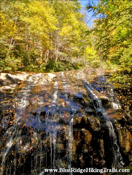
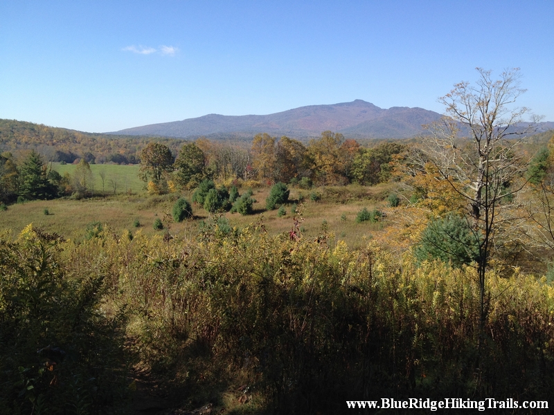
Drive to the Blue Ridge Parkway to milepost 295.9 and park in the overlook. There is a small lake called Sims Pond, and waterfall here and a map of the green knob and which is part of the Julian Price memorial park trail system. After crossing the bridge over the waterfall, continue around the pond on the trail. The trail crosses and runs along the creek then starts to ascend the mountain, the path then go under the blue ridge parkway bridge at Sims Creek Overlook. The trail continues along the creek and climbs the mountain until you reach the green pasture. Then continue up the road and follow the stone arrow signs. The trail heads back into the woods and downwards back in to a field with a mountain view. The trail then continues to loop around and ends up back at the road across from the overlook and the Sims Pond.
Tips:
- Hiking Shoes and Water bottle
- Intermediate hike for families with small kids
Green Knob Trail Map
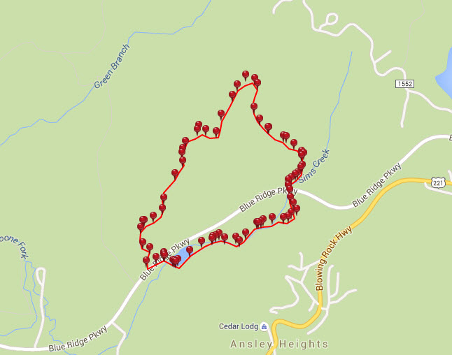
Photo Gallery
*Click on thumbnails for larger viewing and slideshow
by admin | Feb 19, 2014 | Easy Hiking Trails, Hiking By Activity, Hiking By Difficulty, Hiking Trails - Under 1.0 Mile, North Carolina Overlook Mountain Trails, North Carolina State Park Trails, North Carolina Waterfall Trails, Overlook Hiking Trails, State Park Hiking Trails, Waterfall Hiking Trails
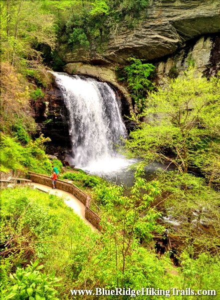
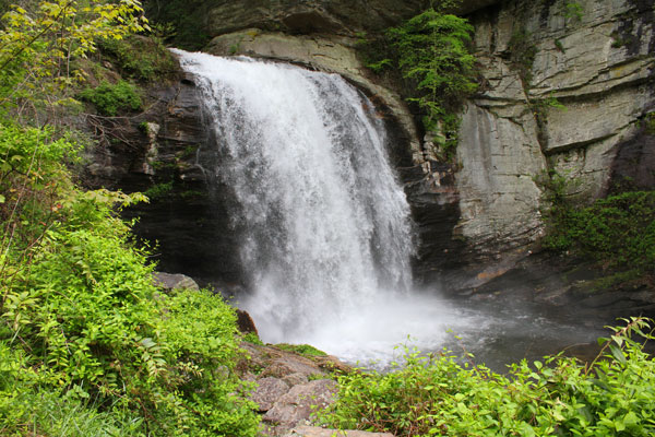
Trail head: Millbrook Estates, North Carolina
Distance: 0.01 miles
Duration: 1 minute
Skill Level: Easy
Overview:
On your way to Brevard North Carolina on highway 64 there is an intersection whereabouts you take a left to Brevard on route 276 or to go into the Pisgah Forest. Go straight at the light and follow 276 North. Follow the Davidson River on the left hand side and go a 5.6 miles. At the fork in the road stay right and Looking Glass Falls is up on the right hand side.Looking Glass Falls is in the Pisgah Forest and open to the public year round. This waterfall is one of the more popular falls due to the visibility from the road.The waterfall has one drop and is 60 feet tall. There is a step path that takes you to the bottom and the plunge pool where many people take pictures and video. Its also kid friendly, accessible by wheelchair at the upper view, and swimming is allowed at the base of the pool. Looking Glass Falls is a great motorcycle waterfall to ride up to take some memorable photos and move onto the next waterfall down the same road route 276.
- Kid Friendly
- Upper View wheelchair access
- Steps to the bottom
- Swim at your own risk
- Visible from the road
Photo Gallery
*Click on thumbnails for larger viewing and slideshow
by admin | Apr 8, 2013 | Hiking By Activity, Hiking By Difficulty, Hiking By Distance, Hiking National Parks, Hiking Trail Guides by State, Hiking Trails - Over 2.0 Miles, Hiking Trails Blue Ridge Parkway NC, North Carolina Mountain Hiking Trails, North Carolina Overlook Mountain Trails, North Carolina Visitor Center Trails, Overlook Hiking Trails, Strenuous Hiking Trails, Visitor Center Hiking Trails, Waterfall Hiking Trails
Trail head: Milepost 299 Blue Ridge Parkway
Distance: 2.1 miles
Duration: 2 hrs
Skill Level: Very Strenous
Overview:
Gully Creek Trail starts at the Blue Ridge Visitor Center, Cumberland Knob, at milepost 217.5 off the Blue Ridge Parkway. Go past the visitor center from the parking lot and look towards the view behind the building and turn left. This is the start of the trail. At the trail head there is a sign Warning: strenuous 2.1 miles, well they were right. The first 10-15 minutes are not difficult as you go back and forth down the mountain. The sides of the trail are dangerous and very steep, one wrong step and you will fall down the mountain. You must be careful and pay attention at all times until you get closer to the bottom near the stream. Gully Creek Trail is one of the most difficult trails I have traversed due to the rushing water coming down the creek towards the bottom of the mountain. The water is running very fast in many places over the rocks where there is no crossing rocks to step on. We had to go ankle deep in some spots and slipped a few times on the rocks. We went very slow and still ended up with some scrapes and bruises. Once you are close to the bottom you are in a ravine following the creek down valley. Here the trail crosses many times back and forth across the creek. This continues until you reach the one mile point and your final crossing leads you past a ragged rock on your right side and then you start the ascent and climb up the other side.
The path starts off kind of easy and then gets harder as your legs get tired until you reach a flatter spot in the trail; you think that you are at the top and the trail then continues upward likes it never ends winding back and forth across the mountain. This part is about 0.7 miles long until you reach a fork in the road (a good resting spot and a quick drink of water) where you can continue straight towards the picnic area bringing you back to the visitor center and parking lot. We chose to go left which takes you up another steep hill for 0.4 miles until you reach Cumberland Knob. At the top you will see a shelter with with a fireplace and a grassy flat area. The trail continues past the shelter and starts down hill and comes out at the visitor center and the parking lot.
Tips:
This trail is not for younger kids that have not been hiking before, my daughter who is seven years old was able to do it with a lot of help from me crossing the creek. This is not a beginner trail at all, make sure you have plenty of water, a backpack with new socks and good hiking boots.
Photo Gallery
*Click on thumbnails for larger viewing and slideshow