by admin | May 25, 2015 | Campground Hiking Trails, Hiking By Activity, Hiking By Difficulty, Hiking By Distance, Hiking National Parks, Hiking Trail Guides by State, Hiking Trails - Over 2.0 Miles, Hiking Trails Blue Ridge Parkway NC, Moderate Hiking Trails, North Carolina Campground Trails, North Carolina Mountain Hiking Trails, North Carolina Overlook Mountain Trails, North Carolina Waterfall Trails, Overlook Hiking Trails, Waterfall Hiking Trails
Trail head: Milepost 296.7 Blue Ridge Parkway
Distance: 2 miles
Duration: 56 minutes
Skill Level: Moderate Hiking Trails
Overview:
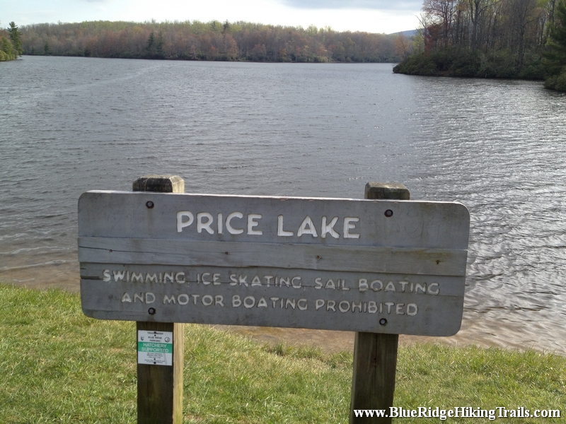
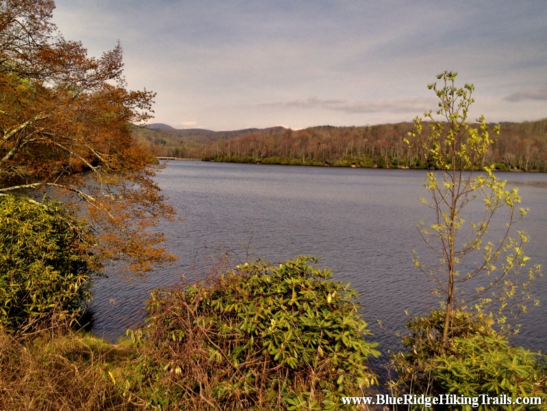
The Price Lake loop trail is part of the Julian Price memorial park trails. From the Parking lot at the front of the lake at milepost 296.7.We went left around the lake and followed the path through the rhododendrons as we passed many opening with different views of the lake. We saw people fishing, canoeing, and sitting on benches enjoying the sounds and breeze of the lake. The trail winds around sometimes very close to the shore of the lake and you will have to cross many small and large bridges on the trail. We even got to see beavers and the dam they built towards the back of the lake. We even passed the boathouse were you can rent canoes and kayak for an adventure on the lake. The lake is at an elevation of 3410 feet. Continue past the campground entrance and you will end of back at the parking lot where you started. Price Lake is a wonderful hike and is worth a first or second trip during the fall foliage.
Tips:
- Make sure you have comfortable shoes
- Make sure your pet is on a leash
- Family friendly trail
- Nice Lake Views
Price Lake Loop Trail Map
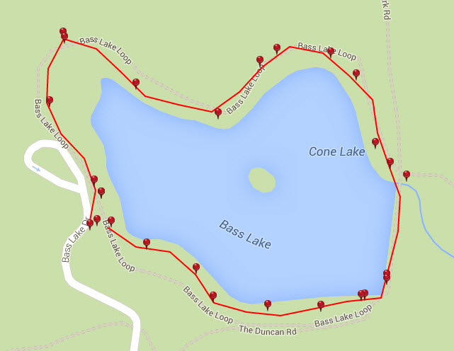
Photo Gallery
*Click on thumbnails for larger viewing and slideshow
by admin | May 25, 2015 | Campground Hiking Trails, Hiking By Activity, Hiking By Difficulty, Hiking By Distance, Hiking National Parks, Hiking Trail Guides by State, Hiking Trails - Over 2.0 Miles, Hiking Trails Blue Ridge Parkway NC, North Carolina Campground Trails, North Carolina Mountain Hiking Trails, North Carolina Overlook Mountain Trails, North Carolina Visitor Center Trails, North Carolina Waterfall Trails, Overlook Hiking Trails, Strenuous Hiking Trails, Visitor Center Hiking Trails, Waterfall Hiking Trails

Trail head: Milepost 316.4 Blue Ridge Parkway
Distance: 1.9 miles
Duration: 25 minutes
Skill Level: Strenuous Hiking Trails
Overview:
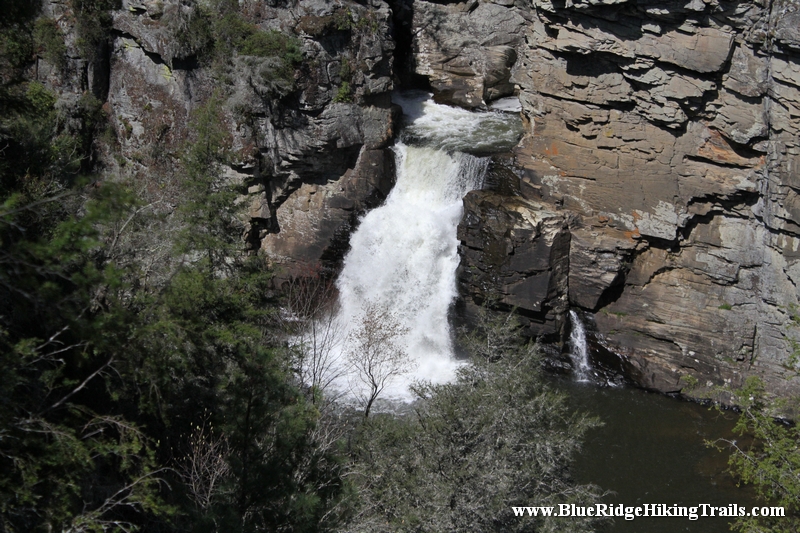
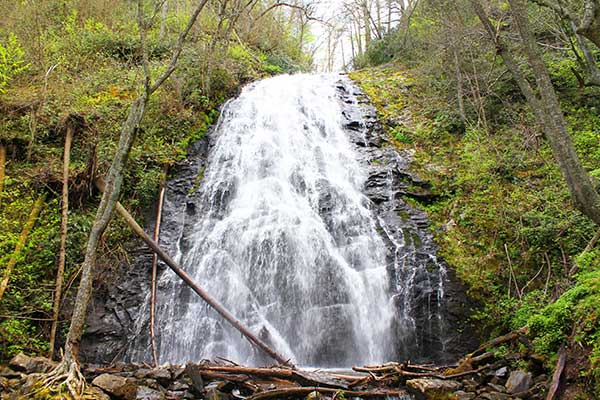
Linville Falls is one of the major attractions along the Blue Ridge Parkway at milepost 316. Linville falls is located in the Blue Ridge mountains of North Carolina and is the beginning of Linville Gorge; the waterfalls are fed from the Linville River and flows down the mountain into Lake James near Marion, North Carolina.
There are two main trails to see the Linville Falls and upper trail and lower trail. This trip we took the upper trail Erwin’s View Trail and is approximately 0.8 miles; 1.6 miles round trip taking 45 minutes to 1hr and 30 minutes. Starting from the Linville Falls Visitor Center the 0.5 mile hike takes you to an overlook where visitors can see the two upper falls and the rushing water as it carves out the rock falling 150ft to the main waterfall. The Erwin’s View trail leads to 2 more overlooks, the Chimney overlook (0.7 miles) and Erwin’s View overlook (0.8 miles).Each overlook has a great view of the waterfalls and the Linville Gorge and a picture is well worth a thousand words once you reach the overlooks.
Tips:
- Make sure you go to the bathroom at the visitor center before you start your hike whether you take the upper or lower trail.
- Make sure you bring a water bottle.
- Make sure you bring a camera for pictures.
- Make sure you wear sneakers or hiking shoes.
Linville Falls Trail Map
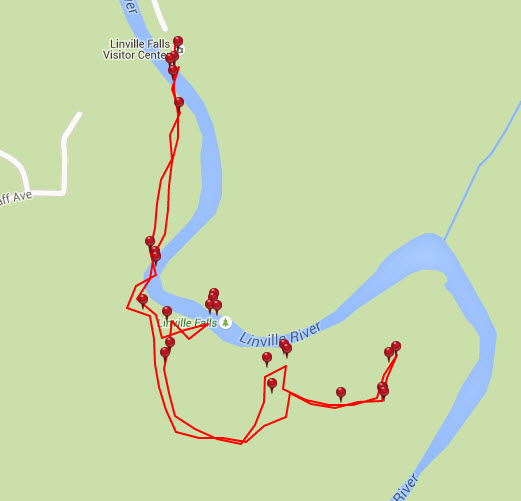
Photo Gallery
*Click on thumbnails for larger viewing and slideshow
by admin | May 25, 2015 | Campground Hiking Trails, Hiking By Activity, Hiking By Difficulty, Hiking By Distance, Hiking National Parks, Hiking Trail Guides by State, Hiking Trails - Over 2.0 Miles, Hiking Trails Blue Ridge Parkway NC, Moderate/Strenuous Hiking Trails, North Carolina Campground Trails, North Carolina Mountain Hiking Trails, North Carolina Overlook Mountain Trails, North Carolina Visitor Center Trails, North Carolina Waterfall Trails, Overlook Hiking Trails, Visitor Center Hiking Trails, Waterfall Hiking Trails
Trail head: Milepost 339.5 Blue Ridge Parkway
Distance: 2.6 miles
Duration: 2 hrs
Skill Level: Moderate/Strenuous Hiking Trails
Tips:
- Make sure you have comfortable hiking shoes
- There is a bathroom and a water fountain at the parking lot
- Waterfall Picture taking bring camera
Crabtree Falls Loop Trail Map
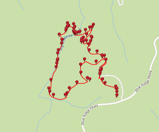
Photo Gallery
*Click on thumbnails for larger viewing and slideshow
by admin | May 25, 2015 | Hiking By Activity, Hiking By Difficulty, Hiking By Distance, Hiking National Parks, Hiking Trail Guides by State, Hiking Trails - Under 1.0 Mile, Hiking Trails Blue Ridge Parkway NC, Moderate/Strenuous Hiking Trails, North Carolina Mountain Hiking Trails, North Carolina Overlook Mountain Trails, North Carolina Visitor Center Trails, Overlook Hiking Trails, Visitor Center Hiking Trails
Trail head: Milepost 304 Blue Ridge Parkway
Distance: .08 mile
Duration: 1 hr
Skill Level: Moderate/ Strenuous Hiking Trails
Overview:
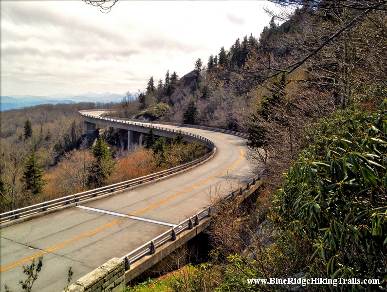
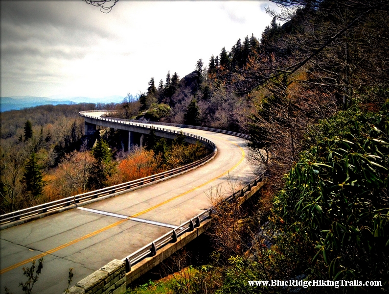
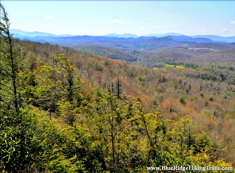
Probably one of the most interesting hikes I have been on yet. Starting from the Linn Cove Viaduct Visitor Center milepost 304.6 off the Blue Ridge Parkway. As you travel through the parking lot to the trail head which takes you on a nice pleasant walk under the viaduct where you can gaze at the amazing modern marvel of construction and hear the many cars traveling overhead. This very short hike is about 900 feet.
This small section is part of the Tanawha Trail which is 13.5 miles long in total distance winding along the Blue Ridge Parkway mountains. For the more adventurous looking for an amazing picture opportunity and seeing the whole viaduct…this is the trail for you. Continue up the wooden stairs as the trail winds up and down through a maze of rocks, boulders, and rock staircases. This is one of the most different types of trails I have been on. I would recommend if kids are going they are at least ages 5 and up and accompanied by an adult on either side. There are some slight drop offs along the trail. There is even one part that you are traveling through the rocks almost like a tunnel. Along the trail there is a bridge where Wilson’s Creek runs under and a pretty coll waterfall to see. As you near the end of the viaduct about an hour later there is a fork in the road; take the fork with the red ribbon to the right. The trail going straight continues as part of the Tanawha Trail. The red ribbon indicates you have made it to one of the most distinctive picture taking points of the Blue Ridge Parkway. You have seen this vantage point in many pictures and magazines about the Blue Ridge Parkway Not only will you be elevated above the parkway but above the viaduct watching cars come around the bend as they travel over the viaduct.
Tips:
- Hiking Shoes
- Water Bottle
- Camera and Video Recorder
- Not For Kids under 5 years old
- Very Rocky up and down elevations
Linn Cove Viaduct Visitor Center Trail Map
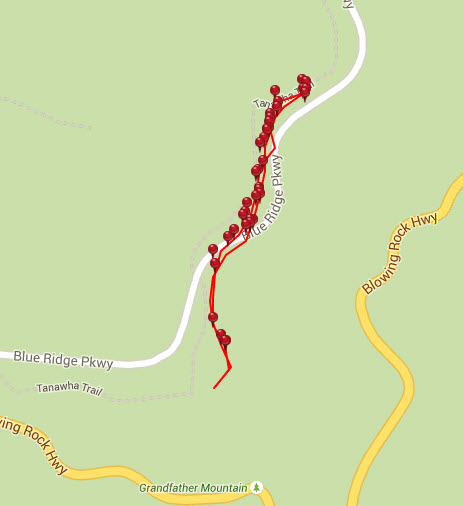
Photo Gallery
*Click on thumbnails for larger viewing and slideshow
by admin | May 25, 2015 | Easy/Moderate Hiking Trails, Hiking By Activity, Hiking By Difficulty, Hiking By Distance, Hiking National Parks, Hiking Trail Guides by State, Hiking Trails - Under 1.0 Mile, Hiking Trails Blue Ridge Parkway NC, North Carolina Mountain Hiking Trails, North Carolina Overlook Mountain Trails, Overlook Hiking Trails
Trail head: Blowing Rock, North Carolina
Distance: 0.6 miles
Duration: 30 minutes
Skill Level: Easy/Moderate Hiking Trails
Overview:
If you are looking to stretch your legs a bit from a long Blue Ridge Parkway Ride , this is the trail for you. At milepost 308.2 off the Blue Ridge Parkway the Flat Rock Trail is a self guiding loop trail that walks you up a slight incline towards the flat rock that opens up into a beautiful view of grandfather country club golf course, beautiful blue ridge mountains in the distance and grandfather mountain to your right hand side.
Great panoramic view for video and pictures..also a great place that is quiet for a picnic.
Tips:
- Bring your camera or video recorder for the panoramic view
- Water Bottle
- Hiking Shoes, but sneakers are ok on this one
Flat Rock Trail Map
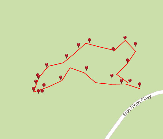
Photo Gallery
*Click on thumbnails for larger viewing and slideshow
by admin | May 25, 2015 | Easy/Moderate Hiking Trails, Hiking By Activity, Hiking By Difficulty, Hiking By Distance, Hiking National Parks, Hiking Trail Guides by State, Hiking Trails - Over 1.0 Mile, Hiking Trails Blue Ridge Parkway NC, Local Park Hiking Trails, North Carolina Local Park Trails, North Carolina Mountain Hiking Trails, North Carolina Overlook Mountain Trails, North Carolina Visitor Center Trails, North Carolina Waterfall Trails, Overlook Hiking Trails, Visitor Center Hiking Trails, Waterfall Hiking Trails
Trail head: Blowing Rock, North Carolina
Distance: 1 mile
Duration: 25 minutes
Skill Level: Easy/Moderate Hiking Trails
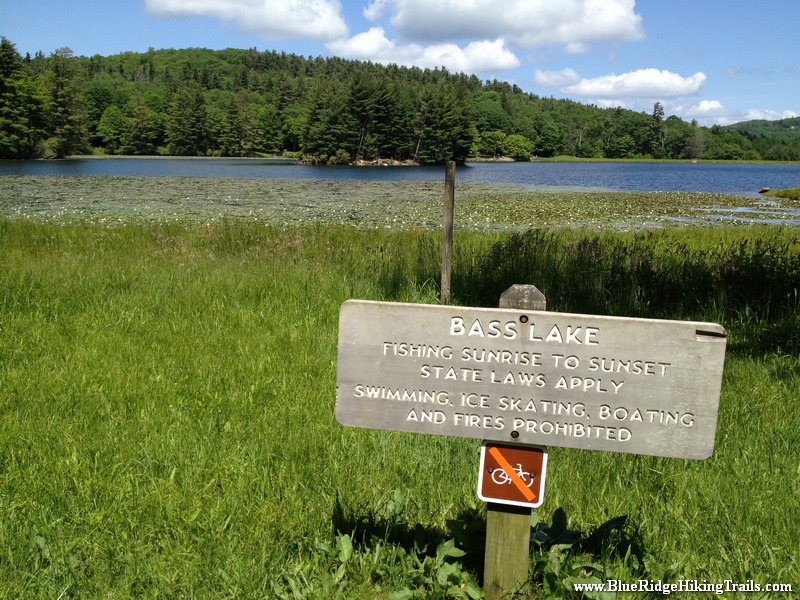
Overview: This is a very family walking trail in Blowing Rock North Carolina. It is part of the Moses Cone Memorial Park Trail system. The hike is about one mile in length but is a beautiful walk around the lake during any season. This hiking trail is a great stretch your legs type of hike after you have been driving in the car all day. Pets are welcomed on this trail but must be on a leash. I would definitely recommend this hike during the fall season for a brisk walk and great picture taking.
Tips:
- Make sure you have comfortable shoes
- There is a bathroom and a water fountain at the parking lot
- Make sure your pet is on a leash
- There are no bicycles allowed on this trail system due to horseback riding
Bass Lake Loop Trail Map
Photo Gallery
*Click on thumbnails for larger viewing and slideshow
Page 2 of 6«12345...»Last »
