by admin | May 25, 2015 | Hiking By Activity, Hiking By Difficulty, Hiking By Distance, Hiking National Parks, Hiking Trail Guides by State, Hiking Trails - Under 1.0 Mile, Hiking Trails Blue Ridge Parkway NC, Moderate/Strenuous Hiking Trails, North Carolina Mountain Hiking Trails, North Carolina Overlook Mountain Trails, North Carolina Visitor Center Trails, Overlook Hiking Trails, Visitor Center Hiking Trails
Trail head: Milepost 304 Blue Ridge Parkway
Distance: .08 mile
Duration: 1 hr
Skill Level: Moderate/ Strenuous Hiking Trails
Overview:
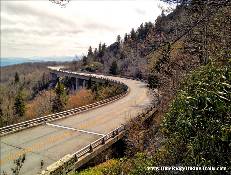
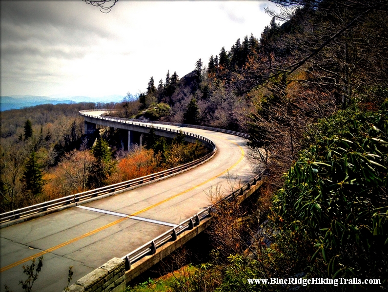
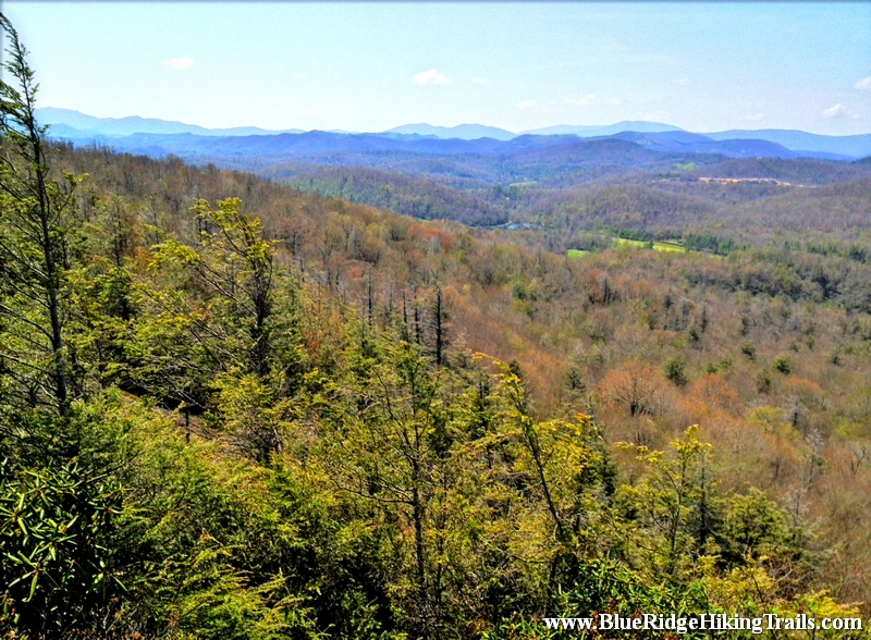
Probably one of the most interesting hikes I have been on yet. Starting from the Linn Cove Viaduct Visitor Center milepost 304.6 off the Blue Ridge Parkway. As you travel through the parking lot to the trail head which takes you on a nice pleasant walk under the viaduct where you can gaze at the amazing modern marvel of construction and hear the many cars traveling overhead. This very short hike is about 900 feet.
This small section is part of the Tanawha Trail which is 13.5 miles long in total distance winding along the Blue Ridge Parkway mountains. For the more adventurous looking for an amazing picture opportunity and seeing the whole viaduct…this is the trail for you. Continue up the wooden stairs as the trail winds up and down through a maze of rocks, boulders, and rock staircases. This is one of the most different types of trails I have been on. I would recommend if kids are going they are at least ages 5 and up and accompanied by an adult on either side. There are some slight drop offs along the trail. There is even one part that you are traveling through the rocks almost like a tunnel. Along the trail there is a bridge where Wilson’s Creek runs under and a pretty coll waterfall to see. As you near the end of the viaduct about an hour later there is a fork in the road; take the fork with the red ribbon to the right. The trail going straight continues as part of the Tanawha Trail. The red ribbon indicates you have made it to one of the most distinctive picture taking points of the Blue Ridge Parkway. You have seen this vantage point in many pictures and magazines about the Blue Ridge Parkway Not only will you be elevated above the parkway but above the viaduct watching cars come around the bend as they travel over the viaduct.
Tips:
- Hiking Shoes
- Water Bottle
- Camera and Video Recorder
- Not For Kids under 5 years old
- Very Rocky up and down elevations
Linn Cove Viaduct Visitor Center Trail Map
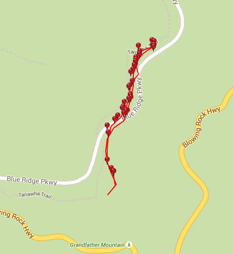
Photo Gallery
*Click on thumbnails for larger viewing and slideshow
by admin | May 25, 2015 | Easy/Moderate Hiking Trails, Hiking By Activity, Hiking By Difficulty, Hiking By Distance, Hiking National Parks, Hiking Trail Guides by State, Hiking Trails - Under 1.0 Mile, Hiking Trails Blue Ridge Parkway NC, North Carolina Mountain Hiking Trails, North Carolina Overlook Mountain Trails, Overlook Hiking Trails
Trail head: Blowing Rock, North Carolina
Distance: 0.6 miles
Duration: 30 minutes
Skill Level: Easy/Moderate Hiking Trails
Overview:
If you are looking to stretch your legs a bit from a long Blue Ridge Parkway Ride , this is the trail for you. At milepost 308.2 off the Blue Ridge Parkway the Flat Rock Trail is a self guiding loop trail that walks you up a slight incline towards the flat rock that opens up into a beautiful view of grandfather country club golf course, beautiful blue ridge mountains in the distance and grandfather mountain to your right hand side.
Great panoramic view for video and pictures..also a great place that is quiet for a picnic.
Tips:
- Bring your camera or video recorder for the panoramic view
- Water Bottle
- Hiking Shoes, but sneakers are ok on this one
Flat Rock Trail Map
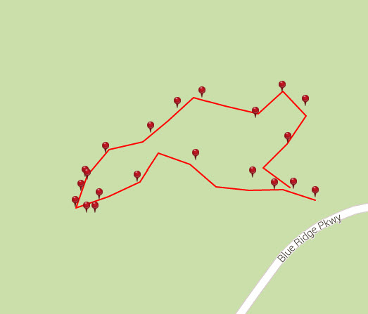
Photo Gallery
*Click on thumbnails for larger viewing and slideshow
by admin | May 25, 2015 | Easy/Moderate Hiking Trails, Hiking By Activity, Hiking By Difficulty, Hiking By Distance, Hiking National Parks, Hiking Trail Guides by State, Hiking Trails - Over 1.0 Mile, Hiking Trails Blue Ridge Parkway NC, Local Park Hiking Trails, North Carolina Local Park Trails, North Carolina Mountain Hiking Trails, North Carolina Overlook Mountain Trails, North Carolina Visitor Center Trails, North Carolina Waterfall Trails, Overlook Hiking Trails, Visitor Center Hiking Trails, Waterfall Hiking Trails
Trail head: Blowing Rock, North Carolina
Distance: 1 mile
Duration: 25 minutes
Skill Level: Easy/Moderate Hiking Trails
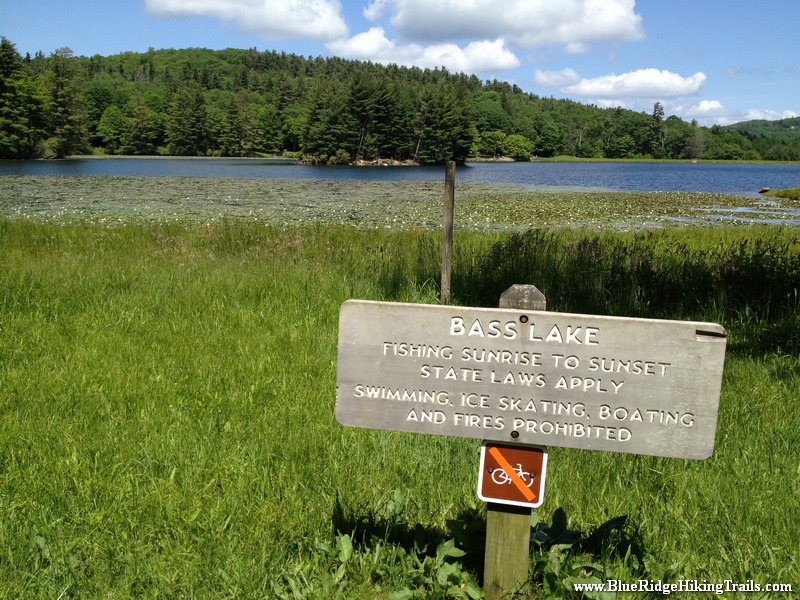
Overview: This is a very family walking trail in Blowing Rock North Carolina. It is part of the Moses Cone Memorial Park Trail system. The hike is about one mile in length but is a beautiful walk around the lake during any season. This hiking trail is a great stretch your legs type of hike after you have been driving in the car all day. Pets are welcomed on this trail but must be on a leash. I would definitely recommend this hike during the fall season for a brisk walk and great picture taking.
Tips:
- Make sure you have comfortable shoes
- There is a bathroom and a water fountain at the parking lot
- Make sure your pet is on a leash
- There are no bicycles allowed on this trail system due to horseback riding
Bass Lake Loop Trail Map
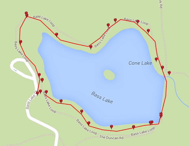
Photo Gallery
*Click on thumbnails for larger viewing and slideshow
by admin | May 25, 2015 | Hiking By Activity, Hiking By Difficulty, Hiking By Distance, Hiking National Parks, Hiking Trail Guides by State, Hiking Trails - Over 1.0 Mile, Hiking Trails Blue Ridge Parkway NC, Moderate/Strenuous Hiking Trails, North Carolina Mountain Hiking Trails, North Carolina Overlook Mountain Trails, North Carolina Waterfall Trails, Overlook Hiking Trails, Waterfall Hiking Trails
Trail head: Milepost 302.8 Blue Ridge Parkway
Distance: 1 mile
Duration: 2 hrs
Skill Level: Moderate/Strenuous Hiking Trails
Overview:
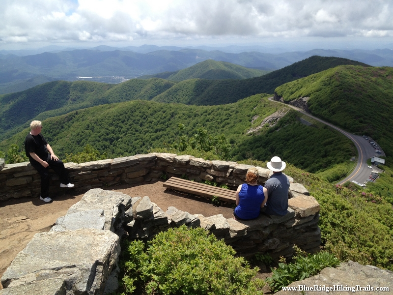
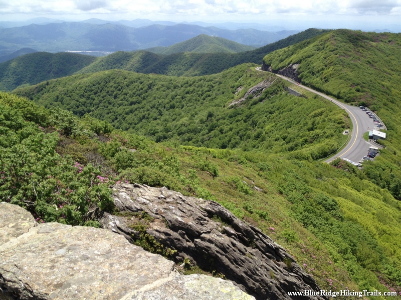
Rough Ridge Overlook and Trail starts at the bottom of the Blue Ridge Parkway, just South of the Blue Ridge Parkway. This is a major section in the Tanawha Trail system which is 13.5 miles long. (See another part of the trail by clicking on the Linn Cove Viaduct Trail)
The first thing you see is a natural waterfall cascading down the rocks at the parking lot. You then ascend the rooted staircase, and cross the bridge; beyond this point there are no animals allowed.
You then continue on the trail up rock made staircases until you reach the first platform of stairs, where the views are breathtaking and its worth a stop for water and pictures. Not only can you see the parkway below and the cars traveling beneath you, but to the right is a great view of the Linn Cove Viaduct and the backside of Grandfather Mountain and McRae Peak. At this point you are only 1/3 of the way up the trail.
You continue through the very narrow trail of bushes and rocks as you climb higher and higher to you reach a ledge of rocks where you have a great show back down at the first platform. The pictures and videos from here are scenic with a 270 degree view of the mountains that reach out as far as the eye can see. Here you are about 2/3 of the way there.
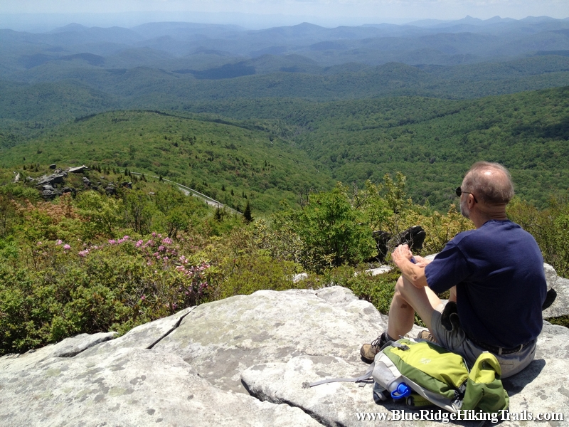
Keep climbing cause the top rock gives you a 360 degree view of the entire area and a great place to stop and take in the mountain views and fresh air. I recommend bringing a picnic or something to eat cause you want to just sit and take in the scenery. I also recommend going on a nice day, if its not hazy you might even see the Charlotte skyline in the distance. What goes up must go down. The hike down is easier but you might have to wait at certain sections as people come up the same trail because the trail is not very wide.
You have now completed in my book one of the best vantage points for picture and video taking on the Blue Ridge Parkway. Enjoy the hike is worth the climb!
Tips:
- Must Have Hiking Shoes
- Bring a few Bottles of Water
- Be Patient and allow other hikers to move past you coming and going due to the trail not being wide.
- Worth packing a picnic or a lunch
- Not small kid friendly about age 5 is the minimum
- No Pets allowed past the bridge
Rough Ridge Trail Map
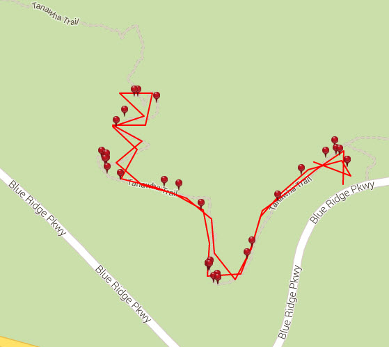
Photo Gallery
*Click on thumbnails for larger viewing and slideshow
by admin | May 25, 2015 | Easy Hiking Trails, Hiking By Activity, Hiking By Difficulty, Hiking By Distance, Hiking National Parks, Hiking Trail Guides by State, Hiking Trails - Under 1.0 Mile, Hiking Trails Blue Ridge Parkway NC, North Carolina Mountain Hiking Trails, North Carolina Overlook Mountain Trails, North Carolina Waterfall Trails, Overlook Hiking Trails, Waterfall Hiking Trails
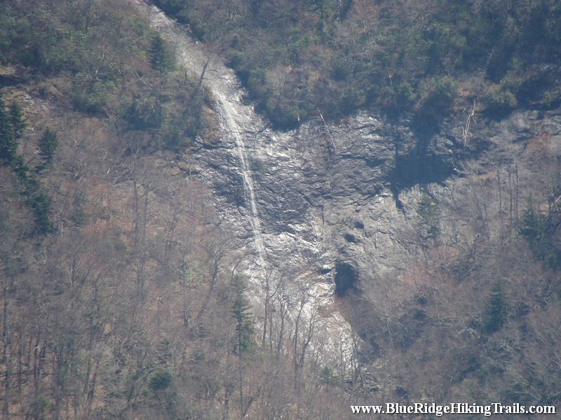
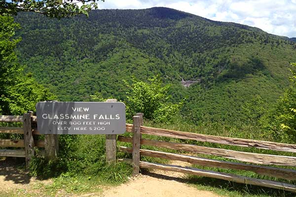
Trail head: Milepost 361.2 Blue Ridge Parkway
Distance: 0.1 miles
Duration: 1 minutes
Skill Level: Easy
Overview:
When you park at the Blue Ridge Parkway overlook. Get out of the car and walk up the little hill on the path. Once you get to the top you will see the waterfall across the valley on the far side of the overlook.
Tips:
- Need Binoculars to see waterfall up close
Photo Gallery
*Click on thumbnails for larger viewing and slideshow
by admin | May 25, 2015 | Hiking By Activity, Hiking By Difficulty, Hiking By Distance, Hiking National Parks, Hiking Trail Guides by State, Hiking Trails - Under 1.0 Mile, Hiking Trails Blue Ridge Parkway NC, Moderate Hiking Trails, North Carolina Mountain Hiking Trails, North Carolina Overlook Mountain Trails, North Carolina Visitor Center Trails, Overlook Hiking Trails, Visitor Center Hiking Trails
Trail head: Milepost 364 Blue Ridge Parkway
Distance: 0.9 miles
Duration: 60 minutes
Skill Level: Moderate Hiking Trail
Overview:
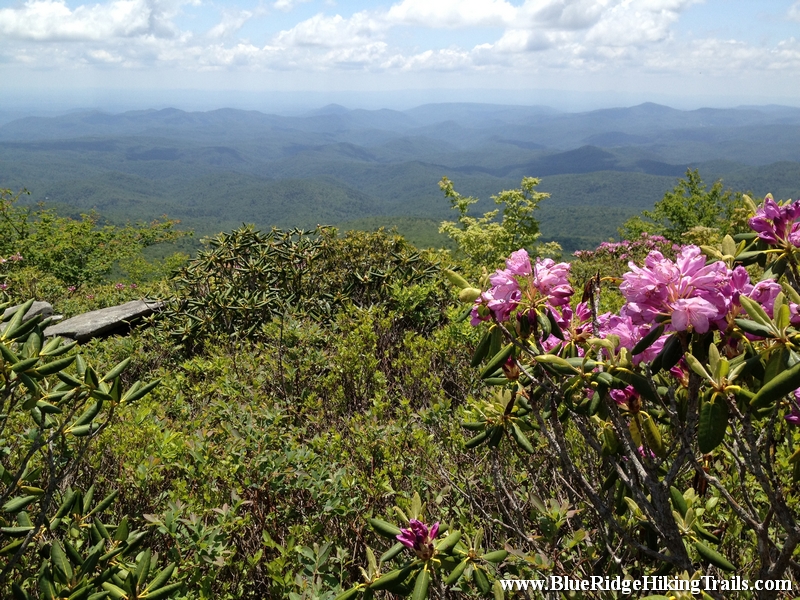
Craggy Gardens and Craggy Pinnacle Trail is one of the most beautiful trails to hike on the Blue Ridge Parkway when the Rhododendrons are blooming forming a canopy of magenta and purple color against the greenery and the Blue Ridge Mountains.
Craggy Gardens is located on milepost 364 on the Blue Ridge Parkway and is about 1hr 30 min from Banner Elk North Carolina.
Your trail hike starts in the parking lot…we parked in the lower parking lot showing you a magnificent 180 degree panoramic video of the Blue Ridge mountains. Then continue to the upper parking lot where you will see the parkway sign “Craggy Dome” the trail head is just on the other side indicated by a sign. The first part of the trail is covered by color as the plants create a canopy in which you walk under on the trail. The first part of the journey is a gradual climb; then you reach a bend and a nice elevated rock with a view.
The trail then leans more upward until it reaches a fork to the right where there is a plateau and many scenic overlooks. As you loop back around the trail with a sign states left to the upper lookout and right to the lower lookout. The lower lookout just allows you to see the visitor center and the mountains in the distance about a 180 degree view. If you want to feel like you are on top of the world take the upper lookout trail until you reach the rock wall with stairs. As you emerge from the stairs you will see a 360 degree lookout with a beautiful scenic landscape of the Blue Ridge mountains, the Asheville watershed lake, and more.
What goes up must come down as the walk down the mountain trail is a lot more easier than going up.
Tips:
- Great Mountain Views
- Family friendly trail
- Moderate Hiking Trails
- Hiking shoes or sneakers
- Camera or video recorder
- Bottle of water
- Plan the hike on a nice sunny day
Craggy Gardens Trail Map
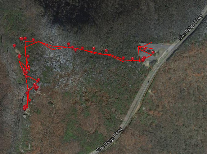
Photo Gallery
*Click on thumbnails for larger viewing and slideshow
