by admin | May 25, 2015 | Easy/Moderate Hiking Trails, Hiking By Activity, Hiking By Difficulty, Hiking By Distance, Hiking National Parks, Hiking Trail Guides by State, Hiking Trails - Over 1.0 Mile, Hiking Trails Blue Ridge Parkway NC, Local Park Hiking Trails, North Carolina Local Park Trails, North Carolina Mountain Hiking Trails, North Carolina Overlook Mountain Trails, North Carolina Visitor Center Trails, North Carolina Waterfall Trails, Overlook Hiking Trails, Visitor Center Hiking Trails, Waterfall Hiking Trails
Trail head: Blowing Rock, North Carolina
Distance: 1 mile
Duration: 25 minutes
Skill Level: Easy/Moderate Hiking Trails
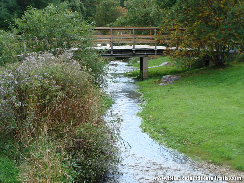
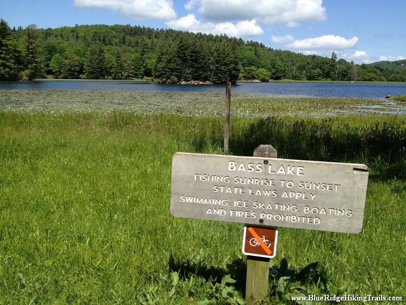
Overview: This is a very family walking trail in Blowing Rock North Carolina. It is part of the Moses Cone Memorial Park Trail system. The hike is about one mile in length but is a beautiful walk around the lake during any season. This hiking trail is a great stretch your legs type of hike after you have been driving in the car all day. Pets are welcomed on this trail but must be on a leash. I would definitely recommend this hike during the fall season for a brisk walk and great picture taking.
Tips:
- Make sure you have comfortable shoes
- There is a bathroom and a water fountain at the parking lot
- Make sure your pet is on a leash
- There are no bicycles allowed on this trail system due to horseback riding
Bass Lake Loop Trail Map
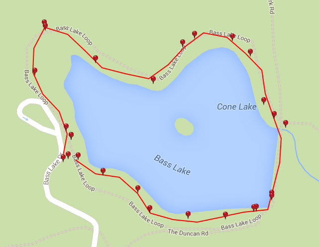
Photo Gallery
*Click on thumbnails for larger viewing and slideshow
by admin | May 25, 2015 | Hiking By Activity, Hiking By Difficulty, Hiking By Distance, Hiking National Parks, Hiking Trail Guides by State, Hiking Trails - Over 1.0 Mile, Hiking Trails Blue Ridge Parkway NC, Moderate/Strenuous Hiking Trails, North Carolina Mountain Hiking Trails, North Carolina Overlook Mountain Trails, North Carolina Waterfall Trails, Overlook Hiking Trails, Waterfall Hiking Trails
Trail head: Milepost 302.8 Blue Ridge Parkway
Distance: 1 mile
Duration: 2 hrs
Skill Level: Moderate/Strenuous Hiking Trails
Overview:
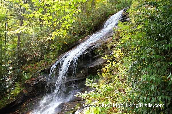
Rough Ridge Overlook and Trail starts at the bottom of the Blue Ridge Parkway, just South of the Blue Ridge Parkway. This is a major section in the Tanawha Trail system which is 13.5 miles long. (See another part of the trail by clicking on the Linn Cove Viaduct Trail)
The first thing you see is a natural waterfall cascading down the rocks at the parking lot. You then ascend the rooted staircase, and cross the bridge; beyond this point there are no animals allowed.
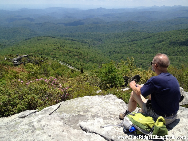
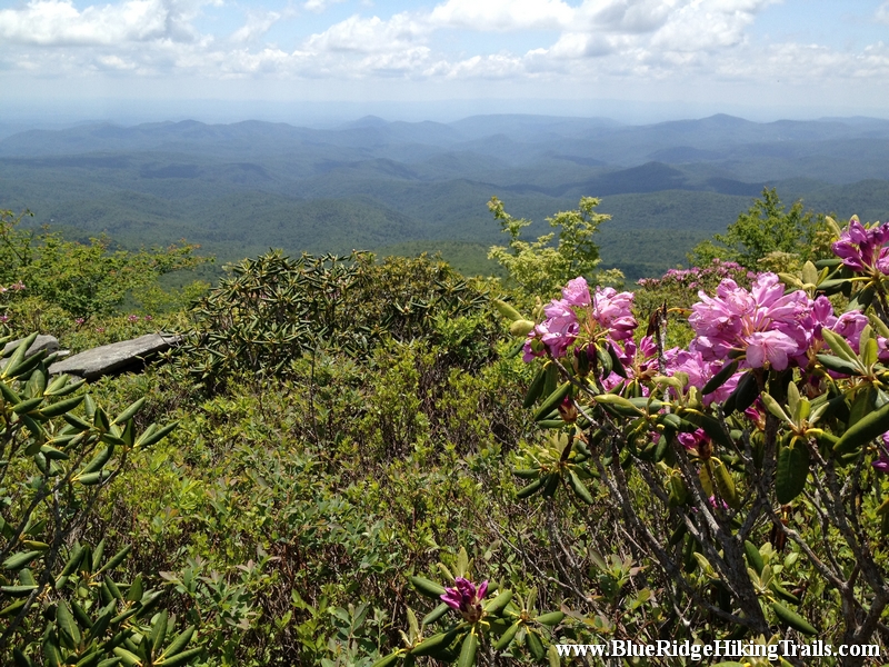
You then continue on the trail up rock made staircases until you reach the first platform of stairs, where the views are breathtaking and its worth a stop for water and pictures. Not only can you see the parkway below and the cars traveling beneath you, but to the right is a great view of the Linn Cove Viaduct and the backside of Grandfather Mountain and McRae Peak. At this point you are only 1/3 of the way up the trail.
You continue through the very narrow trail of bushes and rocks as you climb higher and higher to you reach a ledge of rocks where you have a great show back down at the first platform. The pictures and videos from here are scenic with a 270 degree view of the mountains that reach out as far as the eye can see. Here you are about 2/3 of the way there.
Keep climbing cause the top rock gives you a 360 degree view of the entire area and a great place to stop and take in the mountain views and fresh air. I recommend bringing a picnic or something to eat cause you want to just sit and take in the scenery. I also recommend going on a nice day, if its not hazy you might even see the Charlotte skyline in the distance. What goes up must go down. The hike down is easier but you might have to wait at certain sections as people come up the same trail because the trail is not very wide.
You have now completed in my book one of the best vantage points for picture and video taking on the Blue Ridge Parkway. Enjoy the hike is worth the climb!
Tips:
- Must Have Hiking Shoes
- Bring a few Bottles of Water
- Be Patient and allow other hikers to move past you coming and going due to the trail not being wide.
- Worth packing a picnic or a lunch
- Not small kid friendly about age 5 is the minimum
- No Pets allowed past the bridge
Rough Ridge Trail Map
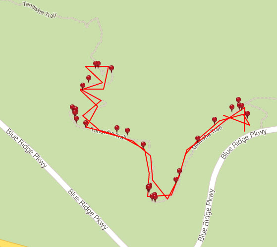
Photo Gallery
*Click on thumbnails for larger viewing and slideshow
by admin | May 25, 2015 | Easy Hiking Trails, Hiking By Activity, Hiking By Difficulty, Hiking By Distance, Hiking National Parks, Hiking Trail Guides by State, Hiking Trails - Under 1.0 Mile, Hiking Trails Blue Ridge Parkway NC, North Carolina Mountain Hiking Trails, North Carolina Overlook Mountain Trails, North Carolina Waterfall Trails, Overlook Hiking Trails, Waterfall Hiking Trails
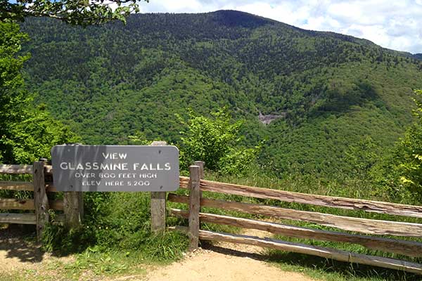
Trail head: Milepost 361.2 Blue Ridge Parkway
Distance: 0.1 miles
Duration: 1 minutes
Skill Level: Easy
Overview:
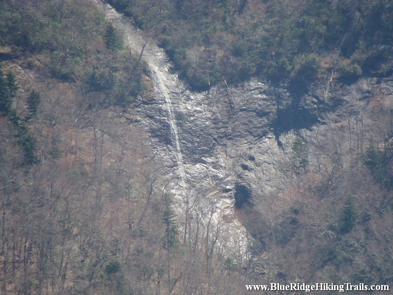
When you park at the Blue Ridge Parkway overlook. Get out of the car and walk up the little hill on the path. Once you get to the top you will see the waterfall across the valley on the far side of the overlook.
Tips:
- Need Binoculars to see waterfall up close
Photo Gallery
*Click on thumbnails for larger viewing and slideshow
by admin | May 18, 2015 | Easy Hiking Trails, Hiking By Activity, Hiking By Difficulty, Hiking By Distance, Hiking Trail Guides by State, Hiking Trails - Under 1.0 Mile, Local Park Hiking Trails, North Carolina Local Park Trails, North Carolina Mountain Hiking Trails, North Carolina Mountain Road Bike Greenway Trails, North Carolina Visitor Center Trails, North Carolina Waterfall Trails, Road Bike Greenway Trails, Visitor Center Hiking Trails, Waterfall Hiking Trails
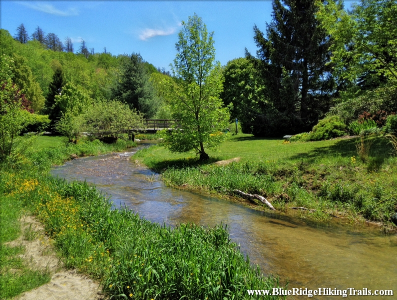
Trail head: Banner Elk, North Carolina
Distance: 0.3 miles
Duration: 7 minutes
Skill Level: Easy
Overview:
Tate Evans Park located next to town hall in Banner Elk North Carolina is one of the most relaxing parks I have ever been to and has everything for everyone, making it an ideal place to go visit. If you have children they can play in the creek when warmer, use the 2 different playgrounds, swings, ride their bikes around the loop, play volleyball, have a picnic, or walk the dog. There is even shelters and grills for barbecues, along with two separate bathrooms. The park is used for many great events in town such as the Fourth of July, Christmas tree lighting, Thursday summer concerts, and more.
Tips:
- Dog park, dog friendly
- Bathrooms, Picnic Benches, Grill, Shelters
- Regular shoes or sneakers would be fine for this hike
- Would recommend this hike to families with small kids
- Great spot for kids to play on the playground, ride bikes, have picnic, play in the creek
Tate Evans Park Trail Map
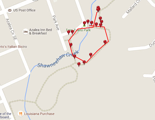
Photo Gallery
*Click on thumbnails for larger viewing and slideshow
by admin | May 18, 2015 | Hiking By Activity, Hiking By Difficulty, Hiking By Distance, Hiking National Parks, Hiking Trails - Under 1.0 Mile, Hiking Trails Blue Ridge Parkway NC, Moderate Hiking Trails, North Carolina Overlook Mountain Trails, North Carolina Visitor Center Trails, North Carolina Waterfall Trails, Overlook Hiking Trails, Visitor Center Hiking Trails, Waterfall Hiking Trails
Trail head: Milepost 271.9 Blue Ridge Parkway
Distance: 0.9 miles
Duration: 55 minutes
Skill Level: Moderate Hiking Trail
Overview:
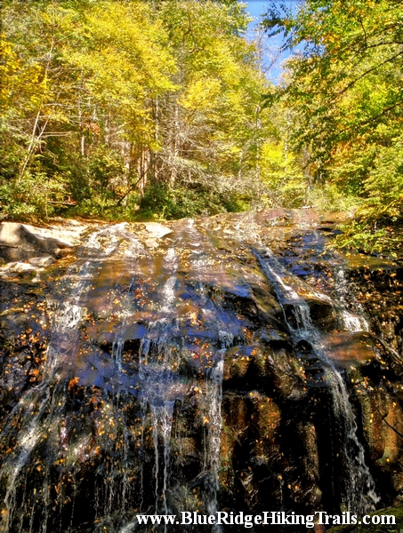
Trail head starts off at the E.B.Jeffress Park overlook at milepost 271.9 on the Blue Ridge Parkway. Past the bathrooms and down the trail the path takes you until you reach a series of steps, the a bridge that crosses Falls Creek which is part of the water for the Cascades waterfall. As you continue down the trail to see and step down many sets of stairs until you come to a stone staircase which leads you to more stairs downwards until you reach the cascades falls. The water fall runs from right to left and is many stories tall. Once you take your photos and head back up a few flights of stairs you then head towards the right and loop around towards the parking lot. there are many picnic benches here for lunch or a snack before or after your hike.
Tips:
- Water bottle
- Regular shoes or sneakers would be fine for this hike
- Would recommend this hike to families with small kids
Cascades Trail Map
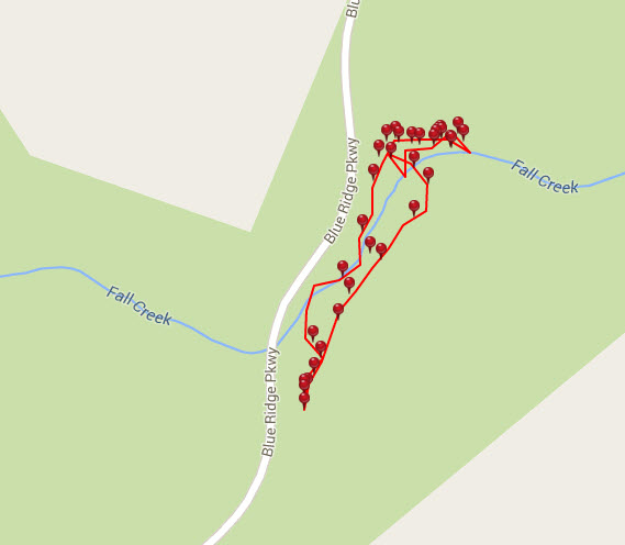
Photo Gallery
*Click on thumbnails for larger viewing and slideshow
Directions To The Cascades Waterfall
by admin | May 17, 2015 | Hiking 101, Hiking By Activity, Hiking By Difficulty, Hiking By Distance, Hiking Trail Guides by State, Hiking Trails - Over 1.0 Mile, Local Park Hiking Trails, Moderate/Strenuous Hiking Trails, North Carolina Local Park Trails, North Carolina Mountain Hiking Trails, North Carolina Waterfall Trails, Waterfall Hiking Trails
Trail head: Broyhill Park Blowing Rock NC
Distance: 1.2 miles
Duration: 1 hr
Skill Level: Moderate/Strenuous Hiking Trails
Overview:
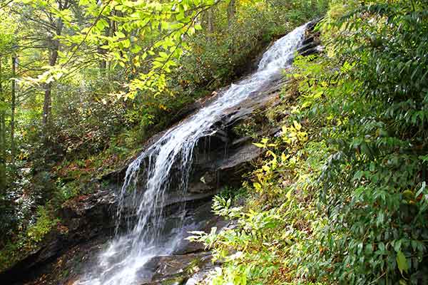
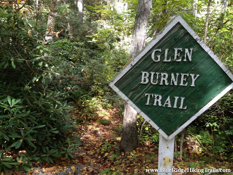
The trail head is just past the Broyhill Park in Blowing Rock North Carolina. This hikes starts down a road then crosses a stream to some stair on onto the path you go. The trail weaves past houses along a fence, down some hills and following along the creek through the rhododendrons. This half of the hike is all down hill, but remember coming back is all on the upward side. Its worth it though seeing the 3 beautiful waterfalls. There are even areas to walk out over or next to the waterfalls on the Glen Burney hiking trail. Make sure you bring your phone or camera for some photo moments.
Tips:
- Water bottle
- Hiking shoes recommended
- Would recommend this for hikers that like waterfalls
Glen Burney Trail Map
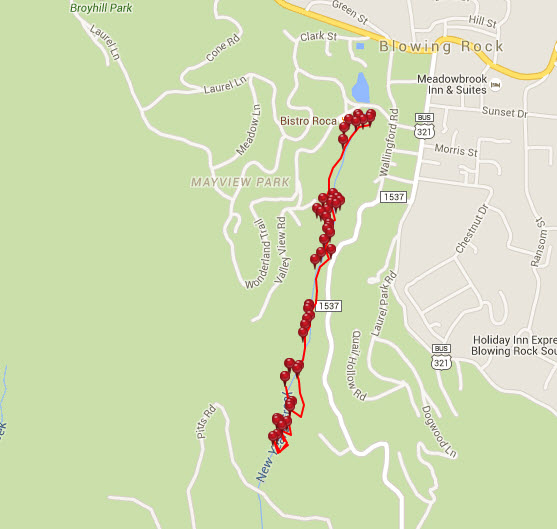
Photo Gallery
*Click on thumbnails for larger viewing and slideshow